St Arvans
| St Arvans Welsh: Llanarfan | |
| Monmouthshire | |
|---|---|
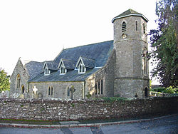
 St Arvans parish church | |
| Location | |
| Grid reference: | ST516965 |
| Location: | 51°39’58"N, 2°42’4"W |
| Data | |
| Post town: | Chepstow |
| Postcode: | NP16 |
| Dialling code: | 01291 |
| Local Government | |
| Council: | Monmouthshire |
| Parliamentary constituency: |
Monmouth |
St Arvans is a village and parish in Monmouthshire found some two miles north-west of Chepstow. The village is close to Chepstow Racecourse, Piercefield House and the Wye Valley Area of Outstanding Natural Beauty. The ancient parish extends from the junction of the A48 Newport Road and the A466 Wye Valley link road in the south to the hamlet of Porthcasseg in the north. It forms part of the Caldicot Hundred except for Porthcasseg itself and a detached part known as Chapel Fields which form part of the Raglan Hundred.
The village has a large village hall, the Memorial Hall, opened in 1924. There is also a cast-iron drinking fountain constructed in 1893. The centre of the village is designated as a Conservation Area.
The cave systems in the area are a strong attraction to cavers and potholers.
Parish church
The village church is named for St Arvan. According to tradition he was a 9th-century hermit who supported himself by fishing for salmon in the River Wye, and drowned when his coracle capsized.
The circular nature of the churchyard suggests that the church may be a Celtic foundation. There are remains of a Celtic cross of the period, and also part of an apparently Anglo-Saxon doorway, but essentially the original church was late Norman in date.
By 1254 the church belonged to the small priory of St Kingsmark or Cynmarch. It was enlarged between 1813 and 1823, and extensive restoration work was carried out in the 1880s and again in the 1980s.[1]