Spurn Head

Spurn Head (or on occasion known as Spurn Point) is a narrow sand spit forming the tip of the Holderness peninsula, and of the East Riding of Yorkshire, at TA399108.
Spurn eaches into the North Sea and forms the north bank of the mouth of the Humber estuary. The spit is over 3 miles long, almost half the width of the estuary at that point, and as little as 50 yards wide in places. The southernmost tip is Spurn Head itself, and here stands an RNLI lifeboat station and disused lighthouse.[1]
Spurn Head covers 279 acres above high water and 447 acres of foreshore. It has been owned since 1960 by the Yorkshire Wildlife Trust and is a designated national nature reserve, heritage coast and is part of the Humber Flats, Marshes and Coast Special Protection Area.
History

In the Middle Ages, Spurn Head was home to the port of Ravenspurn (also known by the name Ravenspur or Ravensburgh), where Henry Bolingbroke landed in 1399 on his return to dethrone Richard II. It was also where Sir Martin De La See led the local resistance against Edward IV's landing on 14 March 1471, as he was returning from his six months' exile in the Netherlands.[2]
An earlier village, closer to the point of Spurn Head, was Ravenser Odd.
Along with many other villages on the Holderness coast, Ravenspurn and Ravenser Odd were lost to the encroachments of the sea, as Spurn Head, due to erosion and deposition of its sand, migrated westward.[3]

The lifeboat station at Spurn Head was built in 1810. Owing to the remote location, houses for the lifeboat crew and their families were added a few years later. The station is now one of only a very few in the United Kingdom which has full-time paid staff (the others all being on the River Thames in London).
In the First World War two coastal artillery 9.2" batteries were added at either end of Spurn Head, with 4" and 4.7" quick firing guns in between. The emplacements can be clearly seen, and the northern ones are particularly interesting as coastal erosion has partly toppled them onto the beach, revealing the size of the concrete foundations very well.
As well as a road, the peninsula also used to have a railway, parts of which can still be seen. Unusual 'sail bogies' were used as well as more conventional light railway equipment.[4]
After a tidal surge in December 2013 which turned the head into an island for a while, the roadway became unsafe, and access to Spurn Point now is on foot only, with a warning not to attempt this when exceptionally high tides are due. [5]
Geography

The peninsula is made up from sand and shingle as well as Boulder Clay eroded from the Holderness coastline washed down the coastline from Flamborough Head. Material is washed down the coast by longshore drift and accumulates to form the long, narrow embankment in the sheltered waters inside the mouth of the Humber estuary. It is maintained by plants, especially Marram grass (Ammophila arenaria). Waves carry material along the peninsula to the tip, continually extending it; as this action stretches the peninsula it also narrows it to the extent that the sea can cut across it in severe weather.
When the sea cuts across the spit permanently, everything beyond the breach is swept away, only to eventually reform as a new spit pointing further south. This cycle of destruction and reconstruction occurs approximately every 250 years. More recently, Dr. John Pethick of Hull University put forward a different theory to explain the formation of Spurn Head. He suggests that the spit head has been a permanent feature since the end of the last ice age, having developed on an underwater glacial moraine. As the ice sheets melted, sea level gradually rose and longshore drift caused a spit to form between this and other islands along the moraine. Under normal circumstances, the sea washes over the neck of the spit taking sand from the seaward side and redepositing it on the landward side. Over time, the whole spit, length intact, slips back – with the spit-head remaining on its glacial foundation.
This process of the sea have been affected by the protection of the spit put in place during the Victorian era. This protection halted the wash-over process and resulted in the spit being even more exposed due to the rest of the coast moving back 100 metres since the 'protection' was constructed. The now crumbling defences will not be replaced and the spit will continue to move westwards at a rate of 6 feet a year, keeping pace with the coastal erosion further north.
The second of the Six Studies in English Folk Song for Cello composed in 1926 by Ralph Vaughan Williams, the Andante sostenuto in E flat "Spurn Point" celebrates this peninsula.
It was featured on the television programme Seven Natural Wonders as one of the wonders of Yorkshire.
Ecology
The landward-side mud flats are an important feeding ground for wading birds, and the area has a bird observatory, for monitoring migrating birds and providing accommodation to visiting birdwatchers. Their migration is assisted by east winds in autumn, resulting in drift migration of Scandinavian migrants, sometimes leading to a spectacular "fall" of thousands of birds. Many uncommon species have been sighted there, including a Cliff Swallow from North America, a Lanceolated Warbler from Siberia and a Black-browed Albatross from the Southern Ocean. More commonly, birds such as Wheatears, Whinchats, Common Redstarts and flycatchers alight at Spurn on their way between breeding and wintering grounds elsewhere. When the wind is in the right direction migrants are funnelled down Spurn Point and are counted at the Narrows Watchpoint, more than 15,000 birds can fly past on a good morning in autumn with 3,000 quite normal.
Lighthouse


The earliest reference to a lighthouse on Spurn Point is 1427. From the seventeenth century there are records of a pair of lighthouses being maintained: a high light and a low light. In 1767, John Smeaton was commissioned to build a new pair of lighthouses. Smeaton's high light (a 90ft tower) remained in use until 1895, but there were problems (as there had been in previous years) with maintaining the low light; within a short time it had been washed away by the sea. A series of more-or-less temporary replacements were used in the years that followed, until a more solid lighthouse was constructed in 1852. In 1895 both this low light and Smeaton's high light were replaced by a single lighthouse which still stands on the grass of Spurn Head. (The 1852 low light also still stands on the sandy shore of the spit, though its lantern has been replaced by a large water tank. Of the old Smeaton high light only the foundations remain.)[6]
The 1895 lighthouse is a round brick tower, 128ft high, painted black and white. It was designed by Thomas Matthews. Its main light had a range of 17 nautical miles, and in addition there were separate sector lights, two of which marked particular shoals or sandbanks, while another indicated the main channel along the Humber. Due to improvements in navigation, the light was discontinued in 1985. Since then, the lighthouse has remained empty. In 2013, however, Yorkshire Wildlife Trust was awarded a £470,500 grant to restore the lighthouse with a view to its being reopened as a visitor centre. This is scheduled to take place in 2015.[7]
Pictures
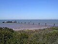
The pier and launching platform for the RNLI at Spurn
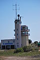
Humber Vessel traffic service
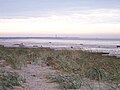
Spurn Point from the mainland
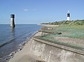
The old Low Light (1852) seen alongside the new (1895) lighthouse


Outside links
| ("Wikimedia Commons" has material about Spurn Head) |
- Map: 53°34’33"N, 0°6’41"E
- Yorkshire Wildlife Trust – Spurn Nature Reserve
- Spurn Head Heritage Coast
- Spurn Point – National Nature Reserve and Lifeboat Station
- Spurn Bird Observatory
- Tide times at Spurn Point from the UKHO
References
- ↑ Preece, Rob (29 July 2012). "Lights out for the families of Britain's loneliest lifeboat station". Daily Mail. http://www.dailymail.co.uk/news/article-2180565/Families-Britains-time-RNLI-crew-leave-remote-peninsula-home-lifeboatmen-200-years.html. Retrieved 29 July 2012.
- ↑ Bruce, J. (1838). Historie of the Arrivall of Edward IV. Camden Soc. 1. p. 4.
- ↑ "History of Ravenser Odd". Archived from the original on 8 May 2009. http://web.archive.org/web/20090508134629/http://www.yorkshirehistory.com/RAVENSER/index.htm. Retrieved 15 August 2011.
- ↑ "Sails on Rails". Mike Munro. http://www.copsewood.org/ng_rly/sailbogie/sailbogie.htm. Retrieved 8 July 2009.
- ↑ http://www.ywt.org.uk/reserves/spurn-nature-reserve
- ↑ de Boer, G. (1984) [1968]. A History of the Spurn lighthouses. East Yorkshire Local History Society. http://www.eylhs.org.uk/lighthouses.pdf. Retrieved 23 June 2014.
- ↑ "Spurn Point lighthouse gets lottery renovation". BBC News. 18 September 2013. http://www.bbc.co.uk/news/uk-england-humber-24141102. Retrieved 23 June 2014.
- Gazetteer – A–Z of Towns Villages and Hamlets. East Riding of Yorkshire Council. 2006. p. 10.