Difference between revisions of "Snaefell"
(Created page with '{{Infobox hill |name=Snaefell |county=Isle of Man |picture=Snaefell - geograph.org.uk - 32568.jpg |picture caption=Snaefell |height=2,034 feet |os grid ref=SC397881 }} '''Snaefel…') |
m (→Views) |
||
| (2 intermediate revisions by 2 users not shown) | |||
| Line 6: | Line 6: | ||
|height=2,034 feet | |height=2,034 feet | ||
|os grid ref=SC397881 | |os grid ref=SC397881 | ||
| + | |latitude=54.263369 | ||
| + | |longitude=-4.462705 | ||
}} | }} | ||
'''Snaefell''' is the highest mountain of the [[Isle of Man]], and the island's only summit higher than 2,000 feet. Snaefell rises at its summit to 2,034 feet above sea level. The summit is crowned by a train station, café, and several communications masts. | '''Snaefell''' is the highest mountain of the [[Isle of Man]], and the island's only summit higher than 2,000 feet. Snaefell rises at its summit to 2,034 feet above sea level. The summit is crowned by a train station, café, and several communications masts. | ||
==Views== | ==Views== | ||
| − | It is a well-known saying in the Isle of Man that on a clear day six | + | It is a well-known saying in the Isle of Man that on a clear day six kingdoms can be seen from the top: England, Ireland, Scotland, Wales, the Kingdom of Mann and the Kingdom of Heaven.<ref>[http://www.iomguide.com/mountainrailway.php Isle of Man guide website]</ref> |
The plaque at the summit indicates the directions of five points from Snaefell as well as their distances: | The plaque at the summit indicates the directions of five points from Snaefell as well as their distances: | ||
| Line 33: | Line 35: | ||
It is the only electric mountain railway in the British Isles, a tram line at a gauge of 3½ feet on a 53 chain line. The service is seasonal, typically from April to October. The ride from Laxey to the summit takes thirty minutes. | It is the only electric mountain railway in the British Isles, a tram line at a gauge of 3½ feet on a 53 chain line. The service is seasonal, typically from April to October. The ride from Laxey to the summit takes thirty minutes. | ||
| − | == | + | ==Pictures== |
<gallery> | <gallery> | ||
| − | File:Snaefell Mountain Walking Trail - Isle of Man - kingsley - 24-JUN-09.jpg|Footpath entry near Bungalow Station | + | File:Snaefell Mountain Walking Trail - Isle of Man - kingsley - 24-JUN-09.jpg|Footpath entry near Bungalow Station |
| − | File:Snaefell with Snaefell Mountain Railway.jpg|The | + | File:Snaefell with Snaefell Mountain Railway.jpg|The Snaefell Mountain Railway on the ascent |
| − | File:Summit Hotel - Snaefell Mountain - kingsley - 24-APR-09.jpg| | + | File:Summit Hotel - Snaefell Mountain - kingsley - 24-APR-09.jpg|Old hotel near the summit |
| − | File:Snaefell Mountain Summit - Isle of Man - kingsley - 24-APR-09.jpg|Top of Snaefell with | + | File:Snaefell Mountain Summit - Isle of Man - kingsley - 24-APR-09.jpg|Top of Snaefell with geodetic marker and cairn |
| − | File:Plaque atop Snaefell Mountain - Isle of Man - kingsley - 24-JUN-09.jpg|Plaque pointing out the directions of landmarks and their distances from the summit | + | File:Plaque atop Snaefell Mountain - Isle of Man - kingsley - 24-JUN-09.jpg|Plaque pointing out the directions of landmarks and their distances from the summit |
</gallery> | </gallery> | ||
Revision as of 13:44, 19 January 2018
| Snaefell | |
| Isle of Man | |
|---|---|
 Snaefell | |
| Summit: | 2,034 feet SC397881 54°15’48"N, 4°27’46"W |
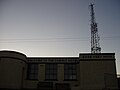
Snaefell is the highest mountain of the Isle of Man, and the island's only summit higher than 2,000 feet. Snaefell rises at its summit to 2,034 feet above sea level. The summit is crowned by a train station, café, and several communications masts.
Views
It is a well-known saying in the Isle of Man that on a clear day six kingdoms can be seen from the top: England, Ireland, Scotland, Wales, the Kingdom of Mann and the Kingdom of Heaven.[1]
The plaque at the summit indicates the directions of five points from Snaefell as well as their distances:
- 31 miles to the Mull of Galloway (Wigtownshire)
- 51 miles to Scafell (Cumberland)
- 66 miles to the Mountains of Mourne (County Down)
- 85 miles to Liverpool (Lancashire)
- 97 miles to Dublin (Co Dublin)
Ascent

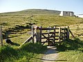
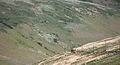
The A18 Snaefell Mountain Road passes over the slopes of Snaefell, and is the highest section of the Snaefell Mountain Course over which the Isle of Man TT Races are held. Walkers often use the car park on this road near the Bungalow railway station (the last railway stop before the summit station) from which there is a rough path to the peak.
The trail has sections of gravel, slate stones, grass, and rock. While the angle of ascent steepens significantly closer to the summit, special climbing equipment is not required. However, caution is required in steep areas as the grass, earth, and rocks are often slippery. An average climb time on foot on a dry footpath is about 45 minutes.
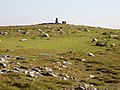
A geodetic marker embedded in the small, concrete obelisk indicates the true mountain summit. The rock cairn standing nearby has an information plaque on top.
Snaefell Mountain Railway

The Snaefell Mountain Railway was begun in 1895, and took just seven months to complete. The line runs four miles from the village of Laxey to the very top of the mountain.
It is the only electric mountain railway in the British Isles, a tram line at a gauge of 3½ feet on a 53 chain line. The service is seasonal, typically from April to October. The ride from Laxey to the summit takes thirty minutes.
Pictures
Footpath entry near Bungalow Station
The Snaefell Mountain Railway on the ascent
Old hotel near the summit
Top of Snaefell with geodetic marker and cairn
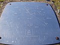
Plaque pointing out the directions of landmarks and their distances from the summit


Outside links
- Computer generated summit panoramas:
- Snaefell Mountain Railway
- Cold War RADAR Site
- Snaefell Fell Race