Silchester
| Silchester | |
| Hampshire | |
|---|---|
 Silchester | |
| Location | |
| Grid reference: | SU6262 |
| Location: | 51°21’11"N, 1°6’4"W |
| Data | |
| Population: | 918 (2001) |
| Post town: | Reading |
| Postcode: | RG7 |
| Dialling code: | 0118 |
| Local Government | |
| Council: | Basingstoke and Deane |
| Parliamentary constituency: |
North East Hampshire |
| Website: | Silchester Parish Council |
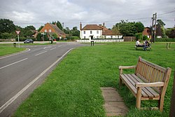
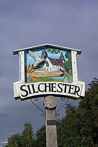
Silchester is a village in Hampshire standing some 5 miles north of Basingstoke. It is adjacent to the county boundary with Berkshire and about 9 miles south-west of Reading.
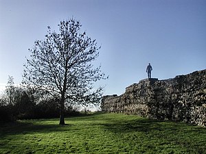
Silchester is famed for the archaeological site and Roman town of Calleva Atrebatum, which is hard by the village but undefiled by it. Calleva was first occupied by the Romans in about 45 AD, on the site of an earlier Iron Age town and the archaeological remains include what is considered the best-preserved Roman wall in the British Isles.
The present village is centred around Silchester Common. It is about a mile west of the parish church and former manor house (now Manor Farm), which are in the eastern part of the former Roman town.
Contents
Post-Roman history and manor
Silcester was recorded in the 11th century, when one Alestan held a manor here with King Edward the Confessor as his overlord and one Cheping held another manor with Earl Harold Godwinson as his overlord.[1] The Domesday Book of 1086 recorded that the Normans William De Ow and Ralph de Mortimer possessed Alestan's and Cheping's manors respectively.[1] The book assessed Alestan's manor at five hides and Mortimer's at three hides.[1] De Mortimer's tenant was another Norman, Ralph Bluet.[1] In 1204 he or a later Ralph Bluet gave a palfrey horse in exchange for a licence to enclose an area of land south-east of the former Roman town as a deer park.[1] Today parts of the earthwork park pale survive and parts of the former park remain wooded.[1]
Forms of the village's name found in times past include Ciltestere and Cilcestre in the 13th century, Scilchestre in the 14th century and Sylkchester in the 18th century before it reached its current spelling.[1]
The Murrough Boyle, 1st Viscount Blesington (1685-1718) bought the manor in 1704 and it remained with his hereditary heirs until the death of William Stewart, 1st Earl of Blessington in 1769.[1] In 1778 it was inherited jointly by Thomas, 1st Viscount de Vesci and Edward Pakenham, 2nd Baron Longford.[1] In 1806 Baron Longford's daughter, The Hon. Catherine Pakenham married Arthur Wellesley, who in 1814 was created Duke of Wellington. In 1828 John, 2nd Viscount de Vesci and Catherine's brother Thomas Pakenham, 2nd Earl of Longford sold the manor of Silchester to the Duke.[1] In the first decade of the 20th century Arthur Wellesley, 4th Duke of Wellington still owned the manor of Silchester.[1]
Churches
- Church of England: St Mary the Virgin
- Methodist: Silchester Methodist Church (built as a Primitive Methodist chapel, on Silchester Common)
The Church of England parish church of St Mary the Virgin is just within the walls of the former Roman town. The building may contain some re-used Roman materials.[2] The building dates from the late 12th[1] or early 13th century.[3] The church has a north and south aisle, each of two bays.[1] There is no chancel arch, and the chancel is longer than the nave.[1] The wall of the south aisle was rebuilt in about 1325-50, incorporating an ogee-arched tomb recess containing the effigy of a lady wearing a wimple.[3] Two new windows were added to the church the 14th century and two more including the Perpendicular Gothic[3] east window of the chancel in the 15th century.[1]
The church has a Perpendicular Gothic[3] rood screen.[1] The pulpit was made early in the 18th century but its tester is dated 1639.[3] There is also a carved memorial cartouche to the Irish peer Viscount Ikerrin (died 1712).[3] The bell-turret has a ring of five bells. Four were cast by John Stares of Aldbourne,[4] Wiltshire in 1744.[5] The other was cast by William Taylor of Oxford[4] in 1848.[5]
Big Society
Silchester's sole public house is the Calleva Arms,[6] named after the former Roman town of Calleva Atrebatum that lies within the village boundary.
The parish has regular events and village activities through the year including a beer festival, fun run, church fete, and music festival.[7][8]
The Silchester Players are the village's amateur dramatic society.[9]
Silchester Cricket Club[10] competes in the Hampshire Cricket League.[11] In 2010 the club finished 2nd in Regional Division 3 North East and was promoted to Regional Division 2 North East for the 2011 season.
Silchester was voted "Hampshire Village of the Year" in 2008 and "South England Village of the Year" in 2009 in the Calor Village of the Year competition.[12]
Calleva Atrebatum
- Main article: Calleva Atrebatum
Calleva Atrebatum was founded as an Iron Age oppidum and subsequently the Romans built a large town on the site. It formed the civitas capital of the Atrebates tribe. The town ruins are located beneath and to the west of the Parish Church of St Mary the Virgin, which lies just within the town wall and about a mile to the east of the modern village of Silchester.
The city is well-named, coming apparently from the British language words for "Great Wall" (later Welsh "Gwall fawr"), and the name may have preceded the Romans, referring to the ramparts of the Atrebates' mighty oppidium here.
Description
Many Roman towns in Britain endured after the Roman retreat, and consequently their remains lie beneath their more recent successors, which are often still major population centres. Calleva is unusual in that, for reasons unknown, it was abandoned shortly after the end of the Roman era. There is some evidence of later occupation within the town; bizarrely an Irish ogham stone has been found here. Nothing is known however. There is a suggestion[13] that the Saxons avoided Calleva after it was abandoned, preferring to maintain their existing centres at Winchester and Dorchester on Thames. There was a gap of perhaps a century before the twin Saxon towns of Basing and Reading were founded on rivers either side of Calleva. As a consequence, Calleva has been subject to relatively benign neglect for most of the last two millennia.[14]
The site covers an area of over 107 acres within a polygonal earthwork.[15] The earthworks and, for much of the circumference, the ruined walls still stand and are impressive to this day. The remains of the amphitheatre, added about 70-80 AD and situated outside the city walls, can also be clearly seen. By contrast, the area inside the walls is now largely farmland with no visible distinguishing features, other than the enclosing earthworks and walls, together with a tiny mediæval church in one corner.[16][17] There is a spring that emanates from inside of the ruined walls, in the vicinity of the original baths, and which ultimately flows south-eastwards where it joins Silchester Brook.
Excavation
Calleva was partially excavated by the Society of Antiquaries of London between the years 1890 and 1909, and this excavation provided valuable information about civic life and daily life in the first centuries AD, as well as a map of the Romano-British town. Whilst the excavation techniques of the time were adequate to deal with buildings with stone foundations, work in other towns of Roman Britain has revealed that timber construction predominated in the 1st and 2nd centuries AD, and the early excavations were not capable of recovering evidence of these buildings.[18]
Additionally, this early excavation was believed to have destroyed evidence that might have been analysed in more careful detail not only with current technology and practices, but with the tools and knowledge of future generations. As archaeological study of this kind can be a destructive process, the excavation of Calleva is frequently mentioned as an example of why complete excavation should not be performed.
However, since the 1970s the University of Reading has become increasingly involved in new excavations. Work has been undertaken on the amphitheatre and the forum basilica, which revealed remarkably good preservation of items from both the Iron Age and early Roman occupations. Since 1997[19] exploration of one of the central insulae of the town has been undertaken. Results indicated that the scope for further work inside and outside the walls is enormous.[18]
Access
Now primarily owned by Hampshire County Council and managed by English Heritage, the site of Calleva is open to the public during daylight hours, seven days a week and without charge. The full circumference of the walls is accessible, as is the amphitheatre. The interior is farmed and, with the exception of the church and a single track that bisects the interior, inaccessible. Current excavations are sometimes open for visitors, and occasional organised open days are held.
The Museum of Reading, located in the Town Hall in central Reading, has a gallery devoted to Calleva, displaying many archeological finds from the various excavations.
Outside links
| ("Wikimedia Commons" has material about Silchester) |
- Roman remains
- Reading Museum web site on Silchester Roman Town
- Details of archaeological open days
- Reading University web site on Silchester Roman Town
- Reading Museum web site on Silchester Roman Town
- City of the Dead: the Roman Town of Calleva Atrebatum, BBC article by Professor Michael Fulford.
References
- ↑ 1.00 1.01 1.02 1.03 1.04 1.05 1.06 1.07 1.08 1.09 1.10 1.11 1.12 1.13 1.14 1.15 Page, 1911, pages 51-56
- ↑ Aston & Bond, 1976, page 53
- ↑ 3.0 3.1 3.2 3.3 3.4 3.5 Pevsner & Lloyd, 1967, page 505
- ↑ 4.0 4.1 "Bell Founders". Dove's Guide for Church Bell Ringers. http://dove.cccbr.org.uk/founders.php. Retrieved 30 January 2011.
- ↑ 5.0 5.1 "Silchester S Mary". Dove's Guide for Church Bell Ringers. http://dove.cccbr.org.uk/detail.php?searchString=Silchester&DoveID=SILCHESTER. Retrieved 30 January 2011.
- ↑ Calleva Arms
- ↑ Silchester Music Festival
- ↑ Pete's Silchester Pages
- ↑ Silchester Players
- ↑ Silchester Cricket Club
- ↑ Hampshire Cricket League
- ↑ "Calor Village of the Year competition". 2009. http://www.villageoftheyear.org/england/winners/overall-winners/2009.htm. Retrieved 16 March 2010.
- ↑ Maev Kennedy (1999-04-09). "Burials 'show Roman city was cursed'". The Guardian. http://www.guardian.co.uk/uk/1999/apr/09/maevkennedy1. Retrieved 2008-12-17.
- ↑ "A Guide to Silchester". Silchester Insula IX. University of Reading. June 2009. http://www.silchester.rdg.ac.uk/guide. Retrieved 2005-09-22.
- ↑ Pevsner & Lloyd, 1967, page 503
- ↑ "Calleva Atrebatum - Roman Silchester". Discover Hampshire. Hampshire County Council. 2006-04-03. Archived from the original on 2007-09-30. http://web.archive.org/web/20070930220021/http://www.hants.gov.uk/discover/places/silchester.html. Retrieved 2009-08-20.
- ↑ "Silchester Roman City Walls and Amphitheatre". English Heritage. http://www.english-heritage.org.uk/daysout/properties/silchester-roman-city-walls-and-amphitheatre/. Retrieved 2005-09-22.
- ↑ 18.0 18.1 "History of the Excavations". Silchester Roman Town - A Guide to Silchester. University of Reading. 2004. http://www.rdg.ac.uk/AcaDepts/la/silchester/publish/guide/excav.php. Retrieved 2005-09-22.
- ↑ "The Insula IX Excavation". Silchester Roman Town - The 'Town Life' Project 1997-2002. University of Reading. 2004. http://www.rdg.ac.uk/AcaDepts/la/silchester/publish/townlife/insula_ix.php. Retrieved 2008-12-07.
Books
- Aston, Michael; Bond, James (1976). The Landscape of Towns. Archaeology in the Field Series. London: J.M. Dent & Sons Ltd. pp. 45–49. ISBN 0 460 04194 0.
- Clarke, A; Fulford, M; Rains, M; Shaffrey, R (2001). "The Victorian Excavations of 1893". Silchester Roman Town - The Insula IX Town Life Project. University of Reading. http://www.silchester.rdg.ac.uk/victorians/vic_home.php. Retrieved 2005-12-20.
- Page, W.H., ed (1911). A History of the County of Hampshire, Volume 4. Victoria County History. pp. 51–56.
- Pevsner, Nikolaus; Lloyd, David (1967). Hampshire and the Isle of Wight. Pevsner Architectural Guides#Buildings of England. Harmondsworth: Penguin Books. pp. 503–505.


