Sidlow
| Sidlow | |
| Surrey | |
|---|---|
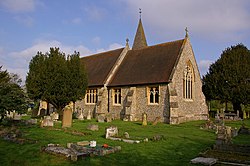
 Emmanuel Church | |
| Location | |
| Grid reference: | TQ259470 |
| Location: | 51°12’29"N, 0°11’56"W |
| Data | |
| Population: | 636 (2011) |
| Post town: | Reigate |
| Postcode: | RH2 |
| Dialling code: | 01737 |
| Local Government | |
| Council: | Reigate and Banstead |
| Parliamentary constituency: |
Reigate |
Sidlow is a mainly rural, lightly populated village in the south-east of Surrey.
This is a rural landscape, of farms with no motorways or railways running by the village. Here three small tributaries meet with the upper River Mole.
Urban to suburban development is residential and concentred into a linear settlement along a lane west of a road junction with the north-south A217 road which has the Anglican church opposite. Beyond this the road forms a crescent which briefly becomes urban again at the Ironsbottom neighbourhood, a sub-settlement. Two lines of further development are towards the crescent return of the lane named Ironsbottom at Wrays and south along the A217 at Crutchfield. The A217 direct, traffic light-controlled route between the economic centres of Reigate and Gatwick Airport is bypassed for long-distance traffic by the M23 motorway three miles to the east.
Church
The Church of England church, the Emmanuel Church at Sidlow Bridge, dates from 1861. The church was designed by Henry Clutton with stained glass by Henry Holiday.[1]
The lych gate to the church was erected in 1921 as a memorial to the village's war dead from the Great War. It is Grade II listed.[2]
Outside links
| ("Wikimedia Commons" has material about Sidlow) |
References
- ↑ "Our History". https://www.emmanuelchurchsidlow.co.uk/our-history.html.
- ↑ National Heritage List 1459067: War Memorial Lych Gate, Emmanuel Church, Sidlow (Grade II listing)