Sarn, Glamorgan
From Wikishire
Revision as of 12:54, 7 April 2021 by RB (Talk | contribs) (Created page with "{{Infobox town |name=Sarn |county=Glamorgan |picture=St Ffraid's Church, Sarn - geograph.org.uk - 4985105.jpg |picture caption=St Bride's Church, Llansantffraid, Sarn |os grid...")
| Sarn | |
| Glamorgan | |
|---|---|
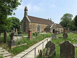
 St Bride's Church, Llansantffraid, Sarn | |
| Location | |
| Grid reference: | SS902835 |
| Location: | 51°32’24"N, 3°35’2"W |
| Data | |
| Population: | 2,443 (2011) |
| Post town: | Bridgend |
| Postcode: | CF32 |
| Dialling code: | 01656 |
| Local Government | |
| Council: | Bridgend |
| Parliamentary constituency: |
Ogmore |
Sarn is a village in Glamorgan, about three miles north of Bridgend and just east of the confluence of the Ogmore and River Llynfi rivers. It is located to the east of Aberkenfig, south of Brynmenyn, and south-east of Tondu.
The M4 motorway tears by at the southern edge of the village.
Sarn is the main shopping centre for the area, including a post office, supermarket and number of independent shops.[1]
The village has a railway station, Sarn Station, opened in 1992.[2]
Outside links
| ("Wikimedia Commons" has material about Sarn, Glamorgan) |
References
- ↑ St Brides Minor/Llansantffraid: St Brides Minor Community Council
- ↑ Butt, R.V.J. (1995). The Directory of Railway Stations. Yeovil: Patrick Stephens Ltd. p. 206. R508. ISBN 1-85260-508-1.