Sarisbury
| Sarisbury | |
| Hampshire | |
|---|---|
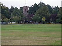
 Sarisbury Green and St Paul's Church | |
| Location | |
| Grid reference: | SU502084 |
| Location: | 50°52’24"N, 1°17’14"W |
| Data | |
| Population: | 7,385 |
| Postcode: | SO31 |
| Local Government | |
| Council: | Fareham |
| Parliamentary constituency: |
Fareham |
Sarisbury is a village to the west of Park Gate within the conurbated towns between Southampton and Fareham in southern Hampshire. Its focal point is Sarisbury Green, the two names being interchangeable, and the parish church of St Paul.
In past times, Sarisbury was a rural locality dependent on fruit growing. Now it is lapped by the urban sprawl. The 2011 Census recorded a population of 7,385. Nearby villages include Bursledon, Hamble-le-Rice and Swanwick.
History
Sarisbury Green originated as a tongue of land at the extremity of Titchfield Common which was left when the rest was enclosed.[1]
The surrounding area used to be the main provider of strawberries to the whole of the United Kingdom. Additionally there used to be apple orchards along the side of the main road through the village, Bridge Road.
Sport
The village has two traditional cricket greens, Also here is Holly Hill Country Park.[2]
The cricket greens are used by Sarisbury Athletic Cricket Club.
Churches
- Church of England: St Paul's Church, originally a chapel of Titchfield Parish,[3][4] It was built in 1836 to a design by Jacob Owen
- United Reformed Church[5]
Events
Every June the village holds a Fayre on the Green, home to the "Swanwick Rollercoaster" and many other attractions.
Outside links
|
|
References
- ↑ Nikolaus Pevsner: The Buildings of England: Hampshire & The Isle of Wight, 1967 Penguin Books ISBN 978-0-300-09606-4
- ↑ "Fareham Borough Council: Holly Hill Woodland Park". http://www.fareham.gov.uk/hollyhill/.
- ↑ St Paul's Church, Sarisbury
- ↑ Sarisbury, St Paul's: Genuki
- ↑ Sarisbury Green URC, Sarisbury Green: Genuki