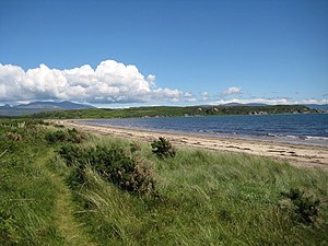
Difference between revisions of "Saddell and Skipness"
(Created page with "{{county|Argyll}} Carradale Bay '''Saddell and Skipness''' is a parish in Argyllshire forming the north-e...") |
m |
||
| Line 3: | Line 3: | ||
'''Saddell and Skipness''' is a parish in [[Argyllshire]] forming the north-eastern part of the [[Kintyre]] peninsula. The eastern bounds of the parish are formed by [[Loch Fyne]] and extend some six miles south-easterly to Skipness Point, and then 24 miles south-westerly along [[Kilbrannan Sound]]. To the north-west lies [[Kilcalmonell]]; to the south-west [[Killean and Kilchenzie]]; and to the south [[Campbeltown]]. | '''Saddell and Skipness''' is a parish in [[Argyllshire]] forming the north-eastern part of the [[Kintyre]] peninsula. The eastern bounds of the parish are formed by [[Loch Fyne]] and extend some six miles south-easterly to Skipness Point, and then 24 miles south-westerly along [[Kilbrannan Sound]]. To the north-west lies [[Kilcalmonell]]; to the south-west [[Killean and Kilchenzie]]; and to the south [[Campbeltown]]. | ||
| − | Hamlets and villages in the parish include Carradale, | + | Hamlets and villages in the parish include [[Carradale]], [[Claonaig]], Cour, [[Grogport]], [[Saddell]] and [[Skipness]]. At Saddell village, near the right bank of Saddell Water, stand [[Saddell Castle]] and the ruins of [[Saddell Abbey]]. |
==Montains and hills== | ==Montains and hills== | ||
The surface is hilly everywhere, in places mountainous, the principal summits from north to south are: | The surface is hilly everywhere, in places mountainous, the principal summits from north to south are: | ||
| − | *Cruach Doire Leithe ( | + | *Cruach Doire Leithe (1,236 feet) |
| − | *Coire nan Capull ( | + | *Coire nan Capull (1,095) |
*Fuar Larach (886) | *Fuar Larach (886) | ||
*Creag Mhor (741) | *Creag Mhor (741) | ||
*Cnoc an Samhlaidh (866) | *Cnoc an Samhlaidh (866) | ||
| − | *Deucharan Hill ( | + | *Deucharan Hill (1,081) |
*Cnoc nan Gabhar (753) | *Cnoc nan Gabhar (753) | ||
| − | *Beinn Bhreac ( | + | *Beinn Bhreac (1,398) |
| − | *Meall Donn ( | + | *Meall Donn (1,138) |
| − | *Ben an Tuirc ( | + | *Ben an Tuirc (1,491) |
*Cnocmalavilach (853) | *Cnocmalavilach (853) | ||
| − | *Bord Mor ( | + | *Bord Mor (1,338). |
Of these, Ben an Tuirc commands a magnificent view of seven Scottish and two Irish counties, from Corsill Point in [[Wigtownshire]] to Ben More in Mull and Ben Lomond in [[Stirlingshire]]. | Of these, Ben an Tuirc commands a magnificent view of seven Scottish and two Irish counties, from Corsill Point in [[Wigtownshire]] to Ben More in Mull and Ben Lomond in [[Stirlingshire]]. | ||
Latest revision as of 09:59, 15 December 2016
Saddell and Skipness is a parish in Argyllshire forming the north-eastern part of the Kintyre peninsula. The eastern bounds of the parish are formed by Loch Fyne and extend some six miles south-easterly to Skipness Point, and then 24 miles south-westerly along Kilbrannan Sound. To the north-west lies Kilcalmonell; to the south-west Killean and Kilchenzie; and to the south Campbeltown.
Hamlets and villages in the parish include Carradale, Claonaig, Cour, Grogport, Saddell and Skipness. At Saddell village, near the right bank of Saddell Water, stand Saddell Castle and the ruins of Saddell Abbey.
Montains and hills
The surface is hilly everywhere, in places mountainous, the principal summits from north to south are:
- Cruach Doire Leithe (1,236 feet)
- Coire nan Capull (1,095)
- Fuar Larach (886)
- Creag Mhor (741)
- Cnoc an Samhlaidh (866)
- Deucharan Hill (1,081)
- Cnoc nan Gabhar (753)
- Beinn Bhreac (1,398)
- Meall Donn (1,138)
- Ben an Tuirc (1,491)
- Cnocmalavilach (853)
- Bord Mor (1,338).
Of these, Ben an Tuirc commands a magnificent view of seven Scottish and two Irish counties, from Corsill Point in Wigtownshire to Ben More in Mull and Ben Lomond in Stirlingshire.
This Argyllshire article is a stub: help to improve Wikishire by building it up.