Ruswarp
| Ruswarp | |
| Yorkshire North Riding | |
|---|---|
.jpg) St Bartholomew's Church | |
| Location | |
| Grid reference: | NZ885095 |
| Location: | 54°27’36"N, 0°38’24"W |
| Data | |
| Post town: | Whitby |
| Postcode: | YO21 |
| Dialling code: | 01947 |
| Local Government | |
| Council: | North Yorkshire |
| Parliamentary constituency: |
Scarborough and Whitby |
Ruswarp is a village in the North Riding of Yorkshire, sitting at the edge of Whitby. It is around two miles from Whitby town centre, at the junction of the B1410 and B1416 roads, on the River Esk. The Esk Valley Line runs through, with trains stopping at Ruswarp railway station.
The name of the village comes from the Old English hris wearp (recorded as Risewarp around 1146) meaning 'silted land overgrown with brushwood'.[1]
The village has a goodly number of local shops including a butcher and a bakery, and a grocery store. There is a pub, the Bridge Inn.
The parish church is the Church of St Bartholomew.
About the village
Crossing the River Esk downstream is a railway viaduct, 120 feet high, built (using 5,250,000 bricks) to carry the Scarborough-to-Whitby line, which closed in 1965.[2] The viaduct is now owned by Sustrans and carries "The Cinder Track", a walk/cycleway along the former Whitby-to-Scarborough railway line.[3]
The River Esk was used to power corn mills in the village but the last closed in 1962. The weir that was built to channel water into a mill race has been adapted to power a hydro-electric project on its southern bank. The Ruswarp Hydro project started generating electricity in December 2012.[4]
The village is on the Esk Valley Walk, a national hiking trail.[5] There is a physically undemanding walk between Ruswarp and Whitby (approximately 1½ miles) mostly along a stone pannierway, known as Monks Trod, signposted from the main street in Ruswarp.[6]
Ruswarp Village Hall caters for community events and classes.

High Street
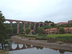
Former rail viaduct


Outside links
| ("Wikimedia Commons" has material about Ruswarp) |
References
- ↑ Ekwall, Eilert, The Concise Oxford Dictionary of English Place-Names. Oxford, Oxford University Press, 4th edition, 1960. p. 397 ISBN 0198691033
- ↑ Lidster, J. Robin (2010). Scarborough and Whitby railway through time. Stroud: Amberley. p. 3. ISBN 978-1-84868-668-7.
- ↑ "Ruswarp, North Yorkshire: Travel and leisure information". http://www.eskvalleyrailway.co.uk/stations/ruswarp.html.
- ↑ "Whitby Esk Energy starts exporting electricity". 20 December 2012. http://whitbyeskenergy.org.uk/whitby-esk-energy-starts-exporting-electricity/. Retrieved 21 September 2017.
- ↑ "Esk Valley Walk - LDWA Long Distance Paths". https://www.ldwa.org.uk/ldp/members/show_path.php?path_name=esk+valley+walk. Retrieved 21 September 2017.
- ↑ "Ruswarp, North Yorkshire: Travel and leisure information". http://www.eskvalleyrailway.co.uk/stations/ruswarp.html.