Royal Anglian Way
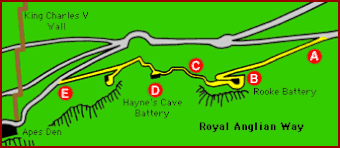
Royal Anglian Way is a path that begins near Apes' Den, where there is a feeding station for the Rock's famous apes (or technically Barbary macaques), and runs a distance of 670 yards to a point near St Michael's Cave. The feeding of the apes takes place twice a day in the early morning and late evening. They live in a number of troops with defined territories on the Rock; the Anglian Way Macaque Group has its feeding area at Apes' Den and the entirety of the path is within the troop's territory.[1]
The apes can be observed from the path dwelling in their natural habitat, away from the tourists who gather at Apes' Den to see the feedings.[2]
Much of the path was already in existence in the early 20th century to provide access to a number of gun batteries and other military installations.[3] It takes its name from the Royal Anglian Regiment, whose 2nd Battalion refurbished the path in 1968–69 and still maintains it with help from the Gibraltar Regiment.[4]
Route and landscape
From its western starting point at Old Queen's Road, at a height of 810 feet above sea level,[3] Royal Anglian Way runs along the western slope of the Rock past a number of abandoned military installations. It first passes Hayne's Cave Battery, a gun position established in 1797. One of the artillery pieces installed there in the 20th century is still present. Several former military support buildings are located further along the path, including kitchens with elongated ceramic chimneys. A little further along is Rooke Battery, built in 1907 and last used during the Second World War to mount a searchlight for illuminating the bay and to house the Fire Command Headquarters. The remains of the searchlight mounting can still be seen.[2][5]
The area around the path has been heavily shaped by human activity, leading to its colonisation by nitrophilous plants which benefit from nitrate-rich environments created by human interference.[3] Flora and fauna that can be seen along the path include esparto grass, wild gladiolus, toothed lavender, rough bugloss and felty and shrubby germander, which grow in the area. Barbary partridge, northern raven and common kestrels nest near the path.[6] A less welcome presence is that of a number of feral goats which have caused serious damage to the vegetation, although eradication efforts are being pursued.[3]
References
- ↑ Guide to the Upper Rock Nature Reserve, p. 18
- ↑ 2.0 2.1 Cano, Tristan (2011). History Walking Guides: Gibraltar. Destinworld. p. 125. ISBN 978-0-955-9281-5-4.
- ↑ 3.0 3.1 3.2 3.3 "Royal Anglian Way". Gibraltar Nature News (Gibraltar Ornithological and Natural History Society) (20): 5–6. Winter 2010–2011. http://www.gonhs.org/documents/naturenews20.pdf.
- ↑ Cano, p. 124
- ↑ "Royal Anglian Way". Discover Gibraltar. http://discovergibraltar.com/pages/mainlogo/mainfrm.htm. Retrieved 18 July 2013.
- ↑ Guide to the Upper Rock Nature Reserve, pp. 16–17
| Footpaths of Gibraltar |
|---|
|
Charles V Wall • Devil's Gap Footpath • Douglas Path • Inglis Way • Martin's Path • Mediterranean Steps • Royal Anglian Way |

