Roecliffe
| Roecliffe | |
| Yorkshire West Riding | |
|---|---|
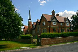
 Roecliffe CofE primary school | |
| Location | |
| Grid reference: | SE375655 |
| Location: | 54°5’17"N, 1°25’34"W |
| Data | |
| Population: | 238 (2011) |
| Post town: | York |
| Postcode: | YO51 |
| Dialling code: | 01757 |
| Local Government | |
| Council: | Harrogate |
| Parliamentary constituency: |
Skipton and Ripon |
Roecliffe is a village in the West Riding of Yorkshire, on the south bank of the River Ure, which marks the boundary with the North Riding. The A1 road runs nearby, crossing the Ure a mile to the west at Boroughbridge.
The village centres on the village green which doubles up as the school playing field. It has a pub, The Crown Inn
Roecliffe is surrounded by scenic views with St Mary's Church, Roecliffe as its main attraction in the heart of the village. The church is believed to be the only church in the country with an entirely vaulted roof.[1]
Close to Roecliffe are the Yorkshire Dales and their National Park. Also close by is the village Skelton-on-Ure.
History
Excavations in 1993 uncovered two 1st-century Roman forts at Roecliffe, located where the modern A1(M) crosses the River Ure. It is believed that the forts were short-lived and were abandoned in favour of Aldborough, a mile east.[2]
Roecliffe was historically a township in the parish of Aldborough.[3] It became a separate civil parish in 1866.[4] In 1974 Roecliffe was transferred from the West Riding to the new county of North Yorkshire.
In the 1870s, Roecliffe was described as:
- "ROCLIFF, or Roecliff, a township-chapelry in Aldborough parish, W. R. Yorkshire; on the river Ure, 1½mile W S W of Boroughbridge r. station. Post-town, Boroughbridge, under York. Acres, 1, 794. Real property, £2, 497. Pop., 231. Houses, 53."[5]
Roecliffe's Pond and Meadows
The area close to the River Ure was once a clay pit in the 19th century, and has been transformed into a private nature reserve.[6] The Roecliffe Ramble is a walk from the village starting at the church and along the River Ure[7] passing locks and Newby Hall (an eighteenth-century country house situated on the banks of the river).
Outside links
| ("Wikimedia Commons" has material about Roecliffe) |
References
- ↑ "<Roecliffe> (Parish): St. Mary's Church information". http://www.achurchnearyou.com/roecliffe/. Retrieved 4 April 2013.
- ↑ Dobinson, C. (1995 (revised reprint 2012)) Aldborough Roman Town. English Heritage. p.6
- ↑ Information on Roecliffe from GENUKI
- ↑ Vision of Britain
- ↑ Wilson, John (1870–72). Imperial Gazetteer of England and Wales. Edinburgh: A. Fullarton and Co.. http://www.visionofbritain.org.uk/place/place_page.jsp?p_id=14135. Retrieved 4 February 2013.
- ↑ "<Roecliffe>(Parish): Description Roecliffe pond and meadows". Neighbourhood Wildlife. Boroughbridge Community. Archived from the original on 27 May 2015. https://web.archive.org/web/20150527034812/http://www.boroughbridge.org.uk/process/153/RoecliffePondsMeadows.html. Retrieved 2 March 2013.
- ↑ "<Roecliffe>(parish):Roecliffe wildlife activities". Roecliffe Wildlife activities. Boroughbridge Walks. http://www.boroughbridgewalks.org.uk/?p=18. Retrieved 2 March 2013.
