Rodmarton
| Rodmarton | |
| Gloucestershire | |
|---|---|
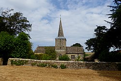
 Church of St Peter, Rodmarton | |
| Location | |
| Grid reference: | ST945978 |
| Location: | 51°40’46"N, 2°4’51"W |
| Data | |
| Population: | 333 (2011) |
| Post town: | Cirencester |
| Postcode: | GL7 |
| Dialling code: | 01285 |
| Local Government | |
| Council: | The Cotswold |
| Parliamentary constituency: |
Cotswold |
Rodmarton is a village in Gloucestershire, about four miles north-east of Tetbury and six miles west of Cirencester, close to Gloucestershire's border with Wiltshire.
The village's proximity name includes the Old English maer, which means "boundary", possibly in reference to the county border.[1]
History
Evidence of a Roman settlement has been found at Rodmarton.[2] A Roman trackway from Cirencester and Chavenage Green runs through the parish, adjacent to which is a long barrow.[1] Roman roads such as the Fosse Way, Portway and the London Way run through or intersect near the parish.[1][3] In 1636, a number of Roman coins and a tessellated pavement were discovered in the parish.[4]
By the Domesday Survey in the late 11th century, the parish consisted of three tithings – Rodmarton, Culkerton, and Tarlton.
The nearby hamlet of Tarlton was home to the Arts and Crafts architect and designer Alfred Powell and his wife Louise from the 1920s to 1960. They built themselves a summer home and pottery studio where they designed pottery for Wedgwood and trained local workers in pottery painting.[5]
Statistics gathered during King Charles I's reign tell that the parish had a population of 227.[6] By 1794, the population had grown to 309. Today it is about the same.
See also
| ("Wikimedia Commons" has material about Rodmarton) |
References
- ↑ 1.0 1.1 1.2 A History of the County of Gloucester - Volume 11 pp 234-236: Rodmarton (Victoria County History)
- ↑ Lewis, Samuel: 'A Topographical Dictionary of England' (S. Lewis and Co., 1848) p269 ISBN 978-0-8063-1508-9
- ↑ Template:Genukigaz
- ↑ Gronow, J.: Review of England and Wales (1849) page 244
- ↑ National Heritage List 1393981: Studio Cottage and ha-ha to rear
- ↑ Eden, Frederick Morton (1797). The state of the poor. B. & J. White. pp. 207. https://books.google.com/books?id=1FJHAAAAYAAJ.
