River Medway


The River Medway is a river 70 miles long principally of Kent, flowing through the heart of the county and some of its famous towns and creating a broad mouth into the Thames Estuary which has served the Royal Navy and industry for centuries.
The Medway runs from the High Weald in Sussex, through Kent to the point where it enters the Thames Estuary. About 13 miles of the river runs through Sussex, but the rest is in Kent.[1] It has a drainage basin of 930 square miles; the largest south of the Thames Basin. The river is fed by innumerable streams and tributaries[2] in an extensive network of waters which rise from points along the North Downs, the Weald and the Ashdown Forest.
Contents
Tributaries

The major tributaries are:
- River Eden
- River Bourne, known as the River Shode and River Busty
- River Teise
- River Beult
- Loose Stream
- River Len
Lesser tributaries include:
Former minor tributaries include the Old Bourne River, that flowed through the Brook, Chatham (not to be confused with the main tributary River Bourne).[3]
The Medway initially flows in a west-east direction south of the North Downs. It becomes tidal at Allington. At the meeting with the River Beult, the river turns northerwards and breaks through the North Downs at the Medway Gap, a steep and narrow valley near Rochester, before its final reach to the sea.
The river and its tributaries flow through largely rural areas, but on its banks are the towns of Tonbridge and Maidstone and then at its mouth the Medway Towns; Rochester and Strood, Chatham and Gillingham.

Until 1746 the river was impassable above Maidstone. To that point each village on the river had its wharf or wharves, at Halling, Snodland, New Hythe and Aylesford. Cargoes included corn, fodder, fruit, stone and timber.
In 1746 improvements to the channel meant that barges of 40 tons could reach East Farleigh, Yalding and even Tonbridge. In 1828 the channel was further improved to Leigh in 1828.
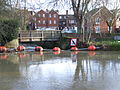
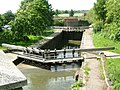
There are eleven locks on the river. The lowest, opened in 1792, is at Allington, and is the extent of tides. The others are East Farleigh, Teston, Yalding (Hampstead Lane), Stoneham Old Lock (disused), East Peckham (Sluice Weir Lock and Oak Wier Lock), East Lock, Porter's, Eldridge's and Town Lock in Tonbridge. The locks will take craft up to 80 feet by 18 feet, and vessels with a draft of 4 feet can navigate the river. The shallowest point is just below Sluice Weir Lock which is prone to silting after heavy rain.[4]
Small craft such as canoes can sometimes travel as far as Penshurst. The stretch from Leigh to Allington is known as the Medway Navigation, and is 19 miles in length. The Environment Agency is the navigation authority.
River crossings

Until recently the lowest crossing of the Medway was at Rochester, where there has been a bridge since Roman times. In the 14th century the Wardens and Commonalty of Rochester Bridge were instituted by Sir John de Cobham to pay for the rebuilding and upkeep of the bridge. Until 1963 the nearest crossing to Rochester Bridge was the 14th century bridge at Aylesford, 12 miles upstream. Since then the following additional crossings have come into use:
- 1963: A viaduct over the river was built south of Rochester to carry the first section of the M2 motorway.
- 2003: The viaduct was widened to two separate spans.
- 1996: the M20 motorway bridge built over the Medway south of Aylesford.
- 1996: The Medway Tunnel dug as the river's lowest crossing, connecting Gillingham to Strood: an immersed tube.
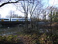
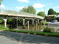
- 2003: Railway bridge, 0.8 miles long with a central span of 498 feet, built for High Speed 1, the Channel Tunnel link.
Three other major crossings are at Tonbridge where bridges carry the A227 road and a Redhill to Tonbridge Line|rail link over the river, there is also a two-span viaduct which takes the A21 over the Medway Valley near Haysden.
Flooding
The middle section of the Medway above Tonbridge, because of the many tributaries entering the river in this stretch, has always been subject to extensive flooding. The town itself has suffered frequent flooding over the centuries - so much so that the higher part of the town to north is called Dryhill. Flood protection measures have therefore had priority. In 1981, a flood barrier was constructed near Leigh to protect Tonbridge, which had been severely affected by the flooding of 1968. During periods of high flow, the downstream flow is controlled by allowing up to 1 square mile of farmland upstream of the barrier to flood.
Footpaths
The Medway Valley Walk follows the river from Rochester to Tonbridge along the bank most of the way above Allington. It starts on the Saxon Shore Way at Rochester. The North Downs Way crosses the river using the Medway Viaduct or motorway bridge. The Greensand Way crosses the river at Yalding. At West Peckham, it is joined by the Wealdway which continues through Tonbridge, thus linking with the Eden Valley Walk. Maidstone Millennium River Park is a 6-mile walk from Teston Country Park to the Museum of Kent Life at Sandling. The park, built between 1998 and 2001 has reansformed 18 acres of wasteland and led to the construction of three new footbridges over the river.[5]
History
Ancient sites abound throughout the length of the River Medway. The area around Aylesford is a particularly important Stone Age site: the Medway megaliths are a group of Neolithic chamber tombs including the Coldrum Stones and Kit's Coty House. Bronze Age ornaments and beakers have been found all along the river; and burial sites and other finds come from the pre-Roman Iron Age. The Romans have left evidence of many villas in the lower Medway Valley; and burial sites of the Jutes have also been found.[6]
The Domesday Book records many manors in the Medway valley. Castles became a feature of the landscape: Rochester, Allington, Leeds, and West Malling being some of them.
Two military actions are named after the river: the Battle of the Medway (43 AD), during the Roman invasion of Britain; the other, the Raid on the Medway, took place in 1667 during the Second Anglo-Dutch War.
In the eighteenth century Samuel Ireland published an illustrated book about a journey up the River Medway,[7] although he travels no further than the River Bewl at Bayham Abbey. The book contains a map, which shows some of the tributaries (unnamed). The illustrations of the river include the castles at Queenborough, Upnor, Leybourne, Tonbridge and Hever; Penshurst Place; and the bridges at Teston, Maidstone, Aylesford, East Farleigh, Barming, Branbridges and Tonbridge. The hop fields in the vicinity of the latter are also described; and the course of the River Len, which then supplied Maidstone with its water supply. The book states that:
| “ | Within about two miles of Tunbridge the Medway branches out into several small streams, five of which unite at the town ... having each its stone bridge. | ” |
The Thames and Medway Canal, linking the Medway at Strood to Gravesend was completed in 1824, but it was a not commercial success and by 1849 the South Eastern Railway had bought the tunnel. The western part of the canal remained in use until 1934.

In 1942 the world's first test of a submarine oil pipeline was conducted on a pipeline laid across the Medway in Operation Pluto.
Culture and the river
- The Medway's 'marriage' to the Thames is given extensive treatment by Edmund Spenser's Faerie Queene in the 16th century (Book IV, Canto xi).
- Joseph Conrad describes the view up the Medway from the Thames Estuary in The Mirror of the Sea (1906).
Every year a festival is held in Maidstone to celebrate the River Medway. Maidstone River Festival, which has been running since 1980, is held on the last Saturday of July. It features events on and around the river and attracts thousands to Kent's county town.[8] The Maidstone River Festival is celebrated during the last weekend in July every year. In 2009, the festival celebrated its 30th anniversary.
"Medway Flows Softly" is a song by local man George Gilbert; it was written in the mid 60s and is often played in local folk clubs and at festivals in Kent.
At 7.15 p.m. on 1 May each year, local morris dancers Kettle Bridge Clogs [9] dance across Barming Bridge (otherwise known as the Kettle Bridge) to mark the official start of their morris dancing season.
Recreationally the river is used by many. For example, individuals and many clubs have trips to paddle along many different parts of the Medway (e.g. Bewl Canoe Club).[10] Individuals and clubs members paddling on the Medway and most other rivers should be members of the BCU.[11]
The Medway as the divider of Kent
The Medway is said to divide the county of Kent into two parts: the tradition has grown up, and today is kept alive by the Association of Men of Kent and Kentish Men, that those born in West Kent, which is to say the area north of the river, are labelled Kentish Men (or Maids); while those born in East Kent are Men (or Maids) of Kent.
The Medway does make a genuine division in Kent, into two dioceses. Since the year 604, there have been two dioceses in Kent: Canterbury and Rochester, and the Medway is their boundary. Whether this has made the traditional division between Men of Kent and Kentish Men may never be known.
Watermills
Man has harnessed the power of the Medway for a millennium or more. Waterwheels and turbines powered by the waters of the Medway and its tributaries have been used by man to mill corn, make paper, make cloth, smelt iron, pump water and generate electricity. There are over two hundred sites on the Medway where such usage is known. Today, only one mill is working for a commercial trade.
Pictures
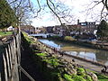
The Medway flows through Tonbridge by many channels
The Botany stream, a channel in Tonbridge
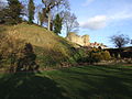
Tonbridge Castle
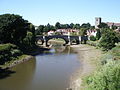
The Medway passes Tonbridge Castle and under Big Bridge
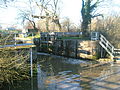
Oak Weir Lock
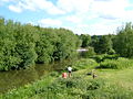
The River Bourne enters the Medway
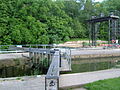
Sluice Weir and the lock
The sluice at Yalding
Hampstead Lane Lock, Yalding
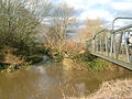
Bow Bridge, Wateringbury
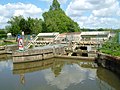
Teston Lock
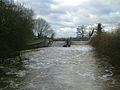
Upstream from Teston Bridge
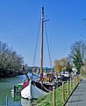
Barges moored at Allington
Mediæval Bridge at Aylesford
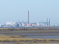
The Isle of Grain and Thamesport from Horrid Hill
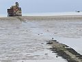
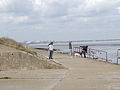
The Grain Tower at low tide.
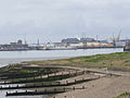
The mouth of the Medway, looking from Grain to Sheerness
Looking into the Thames Estuary


Outside links
| ("Wikimedia Commons" has material about River Medway) |
- Map of the Medway catchment area
- Detailed navigation information
- Leigh Flood Barrier page from the EA
- Flood protection measures
- Medway Valley Countryside Partnership
- BCU Website
References
- ↑ Arscott, David (2011). A Little Book of Sussex. Abingdon: The History Press Ltd.
- ↑ Map of the Medway catchment area: The River Medway (and tributaries)
- ↑ Martin, Karl (2004). "Medway Industrial Archaeological Group: History of the Brook Pumping Station". Archived from the original on January 8, 2008. http://web.archive.org/web/20080108113822/http://www.bwhost.co.uk/miag/station.htm. Retrieved 2008-01-20
- ↑ The Medway navigation, Leaflet,March 1991, NRA-National Rivers Authority
- ↑ BBC News
- ↑ Kent History Illustrated Frank W Jessup 1966 Kent County Council
- ↑ Picturesque View on the River Medway from the Nore to the Vicinity of its Source in Sussex – Samuel Ireland]
- ↑ Environment Agency
- ↑ Kettle Bridge Clogs
- ↑ Bewl Canoe Club
- ↑ BCU Website
Books
- Hadfield, Charles (1969). The Canals of South and South East England. Newton Abbot, UK: David & Charles. ISBN 0-7153-4693-8.