River Cover

The River Cover is a river fourteen miles long in the North Riding of Yorkshire, and which becomes a trbutary of the River Ure beside Ulshaw Bridge. On its course, the river carves Coverdale; a limestone dale with ancient woodlands.
The river and its dale are found amongst the Yorkshire Dales.
Course
The source of the river lies in the shake holes that are found between Buckden Pike and Great Whernside that feed many small gills, such as East Stone Gill, West Stone Gill and Downs Gill. Where these conjoined flows meet Hazel Bank Gill is where the river becomes known as the River Cover. It flows in a north-east direction past Woodale, Braidley and Horsehouse.
The river turns to the north-north-east towards Gammersgill before returning north-east between West Scrafton and @Carlton. Immediately east of Agglethorpe, the river turns east until it joins the River Ure south-east of Middleham.
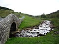
The river runs along a U-shaped glacial valley over Great Scar limestone with Yoredale rock forming the valley sides. It is a gently meandering river with a characteristic stony channel and beaches leading to wooded low banks. The wooded areas extend up into the many gills that join the river.
Wildlife
The river is home for brown trout and grayling.[1]
The Yorkshire Dales Rivers Trust[2] has a remit to conserve the ecological condition of the River Cover.
Tributaries
|
|
Villages by the river
- Woodale
- Braidley
- Arkleside
- Horsehouse
- Swineside
- Gammersgill
- West Scrafton
- Carlton
- Melmerby
- Caldbergh
- Agglethorpe
- Middleham
Pictures
| ("Wikimedia Commons" has material about River Cover) |

River Cover from St Simons Bridge
River Cover

Stepping stones over the River Cover

Caygill footbridge over the River Cover


