River Boyne


The River Boyne (Irish: An Bhóinn or Abhainn na Bóinne) is a river in Leinster in the Republic of Ireland, the course of which is about 70 miles long, passing through or bordering three counties. In its lower course it cuts the lush Boyne Valley.
The Boyne Valley is full of history. Notwithstanding its short course, attached to the Boyne are several historical, archaeological and mythical connotations:
- The Battle of the Boyne, 1690, celebrated by Protestants in Ulster every year, was fought along the Boyne near Drogheda
- The ancient city of Trim and Trim Castle are by its banks.
- The Hill of Tara, ancient capital of the High Kings of Ireland, is here
- Newgrange, a major Stone Age burial mound, is by the Boyne, close to the battlefield.
Here too are Navan, the Hill of Slane, Brú na Bóinne (an ancient temple), Mellifont Abbey, and the mediæval city of Drogheda. In the Boyne Valley can also be found other historical and archaeological monuments, like Loughcrew, Kells, Celtic crosses, castles, and more.
Contents
Course
The Boyne rises at Trinity Well, Newberry Hall, near Carbury, County Kildare, and flows towards the northeast through Meath to reach the Irish Sea between Mornington, Meath and Baltray, County Louth.
The river is crossed just west of Drogheda by the Boyne River Bridge that carries the M1 motorway and by the Boyne Viaduct that carries the Dublin-Belfast railway line to the east.
Salmon and trout can be caught in the river, which is surrounded by the Boyne Valley. Its basin is 1,041 square miles.[1] The long term average flow rate of the River Boyne is 38.8 0 gallons per second[2]
History
This river has been known since ancient times. The Greek geographer Ptolemy drew a map of Ireland in the 2nd century which included the Boyne, which he called Βουουινδα (Bououinda), and somewhat later Giraldus Cambrensis called it Boandus.
In Irish mythology, it is said that the river was created by the goddess Boann ('queen' or 'goddess'), according to F Dinneen, lexicographer of the Irish Gaelic language, and 'Boyne' is an anglicised form of the name. In other legends, it was in this river where Fionn mac Cumhail captured Fiontán, the Salmon of Knowledge. The Meath section of the Boyne was also known as "Smior Fionn Feidhlimthe" [3] (the 'marrow of Fionn Feilim').
The Battle of the Boyne
On 5 November 1688, William of Orange landed in Brixham in Devon to dethrone his uncle and father-in-law, King James II, in defence of the Protestant faith and the liberties of England. By Christmas, James had fled and William and his wife Mary were join King and Queen of England. On 12 March 1689, King James, with French support, landed in Ireland and soon held most of the island. In July 1689, King William's forces landed in Ulster, where Protestants dominated and from whom he could expect support, and William landed in person in June 1690. Ulster secured, William marched south towards Dublin, and the two armies met on the Boyne, just upstream from Drogheda.
On 1 July 1690 (Julian calendar), the armies met, contesting the ford on the Boyne a mile and a half from Oldbridge. In a place of treams and swamp the scope for manoeuvre was limited until a long flanking movement led by William and his Dutch cavalry crossed the river, the King sustaining a wound from a cannonball. Artillery, cavalry and infantry were engaged, and hard fought in this narrow place until the day was done. For a battle of 50,000 men, only about 1,500 Jacobites fell, and 500 of William's men, but the Jacobites were broken, and William entered Dublin two days later.
King James fled, taking the heart out of his army, though it was another year before the war was at last ended.
The battle took place on 1 July 1690 in the "old style" (Julian) calendar. This was equivalent to 11 July in the "new style" (Gregorian) calendar, although today its commemoration is held on 12 July, on which the decisive Battle of Aughrim was fought a year later. The symbolic importance of this battle has made it one of the best-known battles in the history of the British Isles and a key part of the folklore of the Orange Order and the Protestant community as a whole. Its commemoration today is principally by the Orange Order. The Order takes its name from the King; William of Orange.
The orangeman' song "The Sash my Father Wore" contains the chorus:
" It is old but it is beautiful, and its colours they are fine
It was worn at Derry, Aughrim, Enniskillen and the Boyne.
My father wore it as a youth in bygone days of yore,
And on the Twelfth I love to wear the sash my father wore.
About and over the Boyne
The Boyne Navigation is a series of canals running roughly parallel to the main river from near Oldbridge to Navan. Owned by An Taisce and currently derelict, the Inland Waterways Association of Ireland are restoring the navigation to navigable status.
There are a number of railway bridges and viaducts crossing the Boyne which are well known, the most modern being the remarkable bridge bearing the M1 motorway.

Prehistoric art
A rock with indications of being Prehistoric art was found in August 2013. Cliadh O'Gibne reported through the Archaeological Survey of Ireland that a boulder with geometric carvings had been found in Donore, Meath. [4]
The vast Stone Age tomb at Newgrange itself bears examples of enigmatic Neolithic carvings.
Ancient Log-boat
The Boyne Fishermen's Rescue and Recovery Service (BFRRS), near Drogheda in County Louth, were doing one of their regular operations to remove shopping trolleys from the Boyne, in May 2013, when they discovered an ancient log boat, which experts believe may be 5000 years old. Initial examination by an underwater archaeologist, suggests it could be very rare because, unlike other log-boats found here, it has oval shapes on the upper edge which could have held oars. Investigations are on-going.[5]
Viking ship
In 2006, the remains of a Viking ship were found in the river bed in Drogheda during dredging operations. The vessel is to be excavated as it poses a hazard to navigation.[6]
Annalistic references
The Annals of Inisfallen record:
- AI770.2 The battle of Bolg Bóinne [gained] against the Uí Néill, by the Laigin.
Pictures
River Boyne at Trim
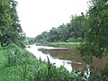
River Boyne at Navan
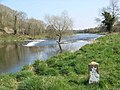
Weir on Boyne Near Stackallen
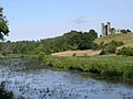
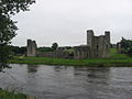
River Boyne at Dunmoe Castle
River Boyne upstream from Slane
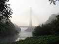
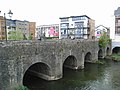
River Boyne passing under the Boyne Cable Bridge in Drogheda
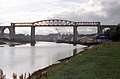
Boyne Viaduct over the River Boyne
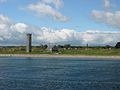
River Boyne at Mornington


Outside links
- Salmon fishing on the River Boyne, from Salmon Ireland
- A canoeing and kayaking guide to the River Boyne, from Irish Whitewater
References
- ↑ South Eastern River Basin District Management System. Page 38 [1]
- ↑ South Eastern River Basin District Management System. Page 38 [2]
- ↑ Dineen: Foclóir Gaedhilge agus Béarla, 1927 ("Smior" - pg 1067, Ed.1996)
- ↑ "Newly Discovered Prehistoric Art in the Boyne Valley". National Monuments Service. http://www.archaeology.ie/News/Name,15142,en.html. Retrieved 30 November 2013.
- ↑ [http://www.archaeology.org/news/867-130513-ireland-boyne-river-log-boat Boyne River log boats – Archaeology]
- ↑ The Irish Times, 27 January 2007
Coordinates: 53°43′N 6°15′W / 53.717°N 6.25°W