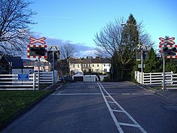
Rhiwderin
From Wikishire
Revision as of 09:00, 18 August 2014 by Owain (Talk | contribs) (Created page with "{{Infobox town |name=Rhiwderin |county=Monmouthshire |picture=Level crossing, Rhiwderin - geograph.org.uk - 351960.jpg |picture caption=Level crossing, Rhiwderin |os grid ref=...")
| Rhiwderin | |
| Monmouthshire | |
|---|---|
 Level crossing, Rhiwderin | |
| Location | |
| Grid reference: | ST2591287552 |
| Location: | 51°34’53"N, 3°4’10"W |
| Data | |
| Post town: | Newport |
| Postcode: | NP10 |
| Dialling code: | 01633 |
| Local Government | |
| Council: | Newport |
| Parliamentary constituency: |
Newport West |
Rhiwderin is a small village and suburb in the west of the city of Newport, Monmouthshire. It lies in the ancient parish of Bassaleg. For civil purposes it forms part of Graig.
The original village lies across a level crossing alongside the line to Lower Machen and off the main A468 Newport—Caerphilly road. There are additional houses on the other side of the main road known as Rhiwderin Heights which have almost merged the village with neighbouring Bassaleg.
The Pentrepoeth School is the local primary school in the area.