Ravensden
From Wikishire
Revision as of 13:25, 27 January 2017 by Owain (Talk | contribs) (Created page with "{{infobox town |county=Bedford |picture=Church at Ravensden - geograph.org.uk - 34961.jpg |picture caption=All Saints Church at Ravensden |latitude=52.1769293 |longitude=-0.42...")
| Ravensden | |
| Bedfordshire | |
|---|---|
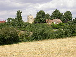
 All Saints Church at Ravensden | |
| Location | |
| Grid reference: | TL076705 |
| Location: | 52°10’37"N, 0°25’41"W |
| Data | |
| Population: | 1,961 (2011[1]) |
| Post town: | Bedford |
| Postcode: | MK44 |
| Dialling code: | 01234 |
| Local Government | |
| Council: | Bedford |
| Parliamentary constituency: |
North East Bedfordshire |
Ravensden is a village and parish in Bedfordshire, to the north of the county town, Bedford.
The parish borders Bedford to the south, with Mowsbury Park and farmland acting as a buffer between the two settlements. The village hosts Ravensden Lower School, and a pub called The Horse and Jockey, as well as All Saints Church. There is also a village hall.
A housing estate called Woodlands Park was established in the southern part of Ravensden parish in the late 2000s. The estate is separated from the village by farmland, with vehicular access to the community coming from the Brickhill area of Bedford. In April 2015 Woodlands Park became part of the civil parish of Brickhill.
References
- ↑ "Civil Parish population 2011". Office for National Statistics. http://www.neighbourhood.statistics.gov.uk/dissemination/LeadKeyFigures.do?a=7&b=11127843&c=Ravensden&d=16&e=62&g=6403014&i=1001x1003x1032x1004&m=0&r=1&s=1478864615007&enc=1. Retrieved 11 November 2016.
Outside links
| ("Wikimedia Commons" has material about Ravensden) |