Poppit
From Wikishire
Revision as of 12:40, 1 June 2015 by RB (Talk | contribs) (Created page with "{{Infobox town |name=Poppit |county=Pembrokeshire |picture=PoppitSands.jpg |picture caption=Poppit Sands from the hill above the beach |os grid ref= SN162466 |latitude=52.0871...")
| Poppit | |
| Pembrokeshire | |
|---|---|
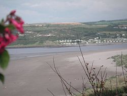
 Poppit Sands from the hill above the beach | |
| Location | |
| Grid reference: | SN162466 |
| Location: | 52°5’14"N, 4°40’58"W |
| Data | |
| Postcode: | SA43 |
| Local Government | |
| Council: | Pembrokeshire |
Poppit is a small, dispersed settlement which lies on the southern side of the estuary of the River Teifi, near Cardigan, in northern Pembrokeshire.
It is primarily known for its popular sandy beach: Poppit Sands.[1] Poppit Sands St Dogmaels beach at its eastern estuary end.[2]
The beach offers views across the estuary and bay towards Gwbert and Cardigan Island, and the nearest village is St Dogmaels, 1½ miles away.
The name 'Poppit' as applied to the hamlet appears to be derived from that of the Sands: it does not appear on Ordnance Survey maps but appears to be a popular appellation. The name of the Poppit Sands has long been debated, its earliest form being Potpitt in 1537.
References
- ↑ "Poppit Sands Beach Cardigan Bay West Wales - dolphin watching and coastal walks". Cardiganshirecoastandcountry.com. http://www.cardiganshirecoastandcountry.com/poppit-sands-beach-cardigan-bay.php. Retrieved 2013-06-09.
- ↑ Go this place - St. Dogmaels beach Retrieved 30 October 2011