Petton, Devon
| Petton | |
| Devon | |
|---|---|
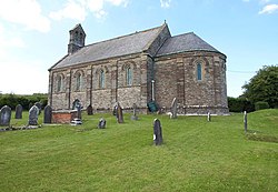
 St Petrocks Church, Petton | |
| Location | |
| Grid reference: | ST005247 |
| Location: | 51°-0’48"N, 3°25’8"W |
| Data | |
| Post town: | Tiverton |
| Postcode: | EX16 |
| Local Government | |
| Council: | Mid Devon |
Petton is a hamlet in the north-east of Devon, just half a mile from the Somerset border, on the B3227 between Bampton, Devon and Wiveliscombe in Somerset and at the foot of the Brendon Hills which rise to the north. The River Batherm, coming off the hills, runs south by the hamlet before turning westwards to Bampton and thence to the Exe.
Notwithstanding its small size, Petton forms an ecclesiastical parish, which encompasses Shillingford to the west, of which the parish church is The Church of St Petrock, also known as 'Petton Chapel'. A small church but in a remarkable version of the Romanesque style, it was built on the site of an earlier chapel of ease. The new church was opened in 1848 after the mediæval chapel was thoroughly rebuilt under the direction of G Boyce of Tiverton. Today it is a Grade-II listed building.[1]
Outside links
| ("Wikimedia Commons" has material about St Petrock’s Church, Petton) |
References
- ↑ National Heritage List 1325633: Petton Chapel