Padley
From Wikishire
| Padley | |
| Derbyshire | |
|---|---|
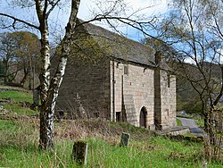
 Padley Chapel, in Upper Padley | |
| Location | |
| Grid reference: | SK251787 |
| Location: | 53°18’17"N, 1°37’25"W |
| Data | |
| Postcode: | S32 |
| Local Government | |
| Council: | Derbyshire Dales |
Padley consists of two neighbouring hamlets in Derbyshire's Peak District, divided by the Burbage Brook:
- Nether Padley
- Upper Padley
The hamlets are in woodland on the east bank of the River Derwent, just north of Froggatt. Across the Derwent is Grindleford, but Grindleford Station is in Padley, the hamlets respectively north and south of it.
The B541 runs through, Burbage Brook joins the Derwent here.
Outside links
| ||
|
