Ormskirk
| Ormskirk | |
| Lancashire | |
|---|---|
 Market day in Ormskirk | |
| Location | |
| Grid reference: | SD415085 |
| Location: | 53°33’59"N, 2°53’13"W |
| Data | |
| Population: | 23,392 |
| Post town: | Ormskirk |
| Postcode: | L39 |
| Dialling code: | 01695 |
| Local Government | |
| Council: | West Lancashire |
| Parliamentary constituency: |
West Lancashire |
Ormskirk is a market town in southern Lancashire. It has been described as a "planned borough", laid out in the 13th century.[1]
Ormskirk lies on sloping ground on the side of a ridge, whose highest point is 223 feet above sea-level, at the centre of the West Lancashire Plain,[2] It is 13 miles north of Liverpool city centre, 11 miles northwest of St Helens, 9 miles southeast of Southport and 15 miles southwest of Preston.
Ormskirk is famous for its gingerbread.[3][4]
Contents
Big Society
Ormskirk Community Partnership is a voluntary organisation created in 2009, with the support of the West Lancashire Borough Council, to act as a voice for Ormskirk.[5]
In Ormskirk is Edge Hill University.[6]
Parish

The parish church is St Peter and St Paul. It is believed to be on the site of the original kirk, on a sandstone outcrop, and is the oldest building in the town. Its exact age is unknown; the building does contain some fragments of Norman architecture.
The church has many connections with the Earls of Derby and the Stanley family. Many family members are buried in the church's Derby Chapel, including Thomas Stanley, 1st Earl of Derby, who caused Richard III to lose his crown by changing sides at the Battle of Bosworth in 1485, and the Royalist James Stanley, the seventh Earl, who was beheaded at Bolton in 1651 after the Civil War. His body is buried in one coffin and his head in a separate casket.
This is one of only three parish churches in England to have a tower and a spire, and is unique in that it has both at the same end of the building. (The other two are St Mary's Church, Purton and St Andrew's Church, Wanborough, both near Swindon, in Wiltshire). Legend has it that Orme had two sisters, one who wanted a tower and one who wanted a spire, and Orme built both to please both. Regrettably, the truth is not so romantic. The 'steeple' dates from the early fifteenth century, but the original blew down in 1731 and was rebuilt between 1790 and 1832. The large west tower was added to the church around 1548 to house the bells of nearby Burscough Priory following the dissolution of the monasteries. One of these bells can still be seen in the church.
History
The name ‘Ormskirk’ is Old Norse in origin and is derived from Ormres kirkja, from a personal name, Ormr (which means "serpent" or dragon), and the Norse word for church.[1] Ormr is otherwise unknown.
There is no reference to Ormskirk in the Domesday Book of 1086 but it has been suggested that it may have been part of Lathom at that time. In about 1189, the lord of Lathom granted the church of Ormskirk to Burscough Priory, which does suggest that Ormskirk had been subordinate to Lathom before that date.[1]
An open market is held twice-weekly, on Thursdays and Saturdays, in the pedestrianised centre of Ormskirk. The location was originally the junction of the main roads to Preston, Liverpool and Wigan, and was marked by a market cross until it was replaced by the current clock tower in the nineteenth century. The market was established by a Royal Charter that was granted by King Edward I in 1286 to the monks of Burscough Priory. Thursday has been market day in Ormskirk since at least 1292. The King also granted a borough charter to Ormskirk at about the same time, but this seems to have become extinct by the end of the fifteenth century.[1]
The Ormskirk Poor Law Union was established in 1837, covering 21 parishes and townships from Tarleton to Simonswood, and from Birkdale to Skelmersdale. Ormskirk Union Workhouse was built in 1853 on Wigan Road and later became Ormskirk District General Hospital.[7]
With its weekly markets, the town became a focal point for local farmers and their agricultural workers, cottagers, cow-keepers etc. to trade their goods and obtain necessities from the markets and from the retail establishments which were established along with public houses and inns. An engineering industry, based on making and mending agricultural machinery also developed.
Transport

The A59 is the main road, with Preston to the north and Liverpool to the south. The A570, from Southport, crosses the town from west to east and provides a link to the national motorway network at junction 3 of the M58, about three miles from the town centre.
The town's railway station]], which was refurbished at a cost of £1 million in 2009, is a northern terminus of Merseyrail, and the line continues, with a change from electric to diesel multiple units, through to Preston, after the direct service was partitioned in 1970. This line was promoted by the Liverpool, Ormskirk and Preston Railway in August 1846, but was completed by the East Lancashire Railway. The route and Ormskirk station opened on 2 April 1849, the undertaking being merged into the Lancashire and Yorkshire Railway on 13 May 1859.
The Lancashire and Yorkshire Railway built the Skelmersdale Branch line to Skelmersdale and Rainford Junction, which opened on 1 March 1858. Passenger services ended on 5 November 1956, goods to Rainford Junction finished on 16 November 1961 and to Skelmersdale on 4 November 1963.
Local economy
Ormskirk is now mainly a retail centre, which also has a number of bars and restaurants. An out of town business park includes DIY stores.
The only significant manufacturing business remaining in Ormskirk, in 2012, are Atkinson & Kirby, who make hardwood floors, employing 80 people.[8] Other businesses in the town are mainly professional and financial services, such as solicitors, estate agents, architects and accountants.
Parks and open spaces
The town has three main parks and a number of other smaller play areas and open spaces. The main parks are:-
- Victoria Park, named after Queen Victoria, is Ormskirk's oldest park, established towards the end of the 19th Century. It contains a monument to local heroes of the Boer War and Crimean War.[9] It is on the triangle of land between Knowsley Road, St Helens Road and Ruff Lane.
- Coronation Park, a large park in the town centre on Park Road, which has children's play areas, skateboard area, games area for football and basketball, fitness equipment, duck pond, bowling green, bandstand and wildlife meadow. The Park was established in about 1905 by the former Ormskirk Urban District to commemorate the coronation of King Edward VII.
- Ruff Wood, a countryside park on the edge of the town, on Ruff Lane.
Pictures
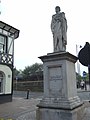
The Beaconsfield monument on Moor Street
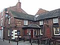
The Buck i'th' Vine Inn on Burscough Street
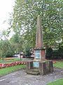
Memorial to Sergeant-Major Nunnerly in Victoria Gardens
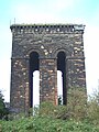
The old water tower on Tower Hill


Outside links
| ("Wikimedia Commons" has material about Ormskirk) |
References
- ↑ 1.0 1.1 1.2 1.3 Lancashire.gov.uk, Ormskirk historic town assessment, Lancashire County Council, 2006
- ↑ Gillibrand Townships: Ormskirk
- ↑ Hawthorne, Nathaniel (1605011517). Works of Nathaniel Hawthorne: (150+ works) Incl: The Scarlet Letter, Twice Told Tales, The House of the Seven Gables, The Blithedale Romance, Tanglewood Tales for Girls and Boys & more. (Mobi Collected Works).
- ↑ Moule, Thomas (1837). The English Counties Delineated, Volume 2. Virtue. pp. 359.
- ↑ Westlandsdc.gov.uk Ormskirk Community Partnership
- ↑ Edgehill.ac.uk, Edge Hill's 'how to find us' page
- ↑ Workhouses.org.uk Ormskirk Workhouses
- ↑ Akirby.co.uk, Atkinson & Kirby home page
- ↑ British Listed Buildings [1] accessed 27 January 2012
- Duggan, Mona (1998) Ormskirk, the Making of a Modern Town. Stroud: Sutton ISBN 0-7509-1868-3