Difference between revisions of "Orlingbury"
(Created page with "{{infobox town |county=Northampton |picture=St Mary's Church - geograph.org.uk - 1800364.jpg |picture caption=St Mary's Church |latitude=52.3394 |longitude=-0.7339 |population...") |
(No difference)
|
Latest revision as of 15:01, 9 December 2019
| Orlingbury | |
| Northamptonshire | |
|---|---|
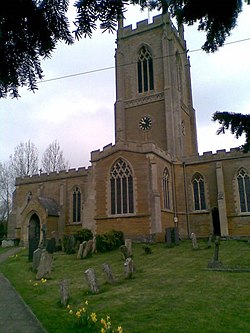
 St Mary's Church | |
| Location | |
| Grid reference: | SP8672 |
| Location: | 52°20’22"N, 0°44’2"W |
| Data | |
| Population: | 439 (2011) |
| Post town: | Kettering |
| Postcode: | NN14 |
| Dialling code: | 01933 |
| Local Government | |
| Council: | North Northamptonshire |
| Parliamentary constituency: |
Wellingborough |
Orlingbury is a village and parish in the Orlingbury Hundred of Northamptonshire. It is between the towns of Kettering and Wellingborough. At the time of the 2011 census, the parish's population was 439.[1]
Notable buildings
The Historic England website contains details of a total of 16 listed buildings in the parish of Orlingbury.[2] Those which are Grade II* are:
- St Mary’s Church, The Green[3] Orlingbury is part of a united Benefice along with Great Harrowden, Little Harrowden, Isham and Pytchley.[4]
- Orlingbury Hall, The Green[5]
- The Old Rectory, Rectory Lane[6]
- Gatepier approximately 45 metres north east of the Old Rectory, Rectory Lane[7]
The Village Hall can be found at Rectory Lane and The Queen's Arms public house at Isham Road.
Wythmail
The site of the deserted village of Wythmail is in the parish of Orlingbury.
Cricket ground
On the outskirts of Orlingbury is a cricket ground, home of Isham Cricket Club[8] who play in Division 1 of The Northamptonshire County League. Past players have included Stephen Fleming (New Zealand national cricket team Captain), Johann Myburgh (SA Titans) and John Hughes (Northamptonshire County Cricket Club).
According to local folklore, the man who killed the last wolf in England is buried in the church. He is known locally as Jock of Badsaddle.[9]
References
- ↑ Office for National Statistics: Orlingbury CP: Parish headcounts. Retrieved 15 July 2015
- ↑ "Historic England – The List". https://historicengland.org.uk/listing/the-list/. Retrieved 2015-09-17.
- ↑ National Heritage List 1040666: St Mary's Church, Orlingbury
- ↑ "Diocese of Peterborough - St Mary, Orlingbury". http://www.peterborough-diocese.org.uk/find-a-church/find-a-church/church-details/96055. Retrieved 2015-09-18.
- ↑ National Heritage List 1040668: Orlingbury Hall
- ↑ National Heritage List 1191565: The Old Rectory, Orlingbury
- ↑ National Heritage List 1371724: Gatepier, Rectory Lane, Orlingbury
- ↑ Isham Cricket Club website
- ↑ "A brief history of St Mary's Church - Orlingbury.info - Community site for the village of Orlingbury". Orlingbury.info. http://www.orlingbury.info/st-marys-church/a-brief-history-of-st-marys-church/. Retrieved 29 August 2014.
Outside links
| ("Wikimedia Commons" has material about Orlingbury) |