Norwell, Nottinghamshire
| Norwell | |
| Nottinghamshire | |
|---|---|
 St Laurence, Norwell | |
| Location | |
| Grid reference: | SK772618 |
| Location: | 53°8’50"N, 0°50’55"W |
| Data | |
| Population: | 490 (2011) |
| Post town: | Newark |
| Postcode: | NG23 |
| Dialling code: | 01636 |
| Local Government | |
| Council: | Newark and Sherwood |
| Parliamentary constituency: |
Newark |
Norwell is a village in the midst of Nottinghamshire about six miles from Newark-on-Trent. The population (including Norwell Woodhouse) at the 2011 census was 490. The wider parish includes Norwell itself, Norwell Woodhouse and the now deserted village of Willoughby.
The village is close to the border with Lincolnshire and the River Trent, a mile and a half from the A1 road and a mile from the East Coast Main Line.
Contents
History
The village appears as "Nortwelle" in the Domesday Book of 1086,[1] in which it is noted as having a church, a priest and a watermill.
For nearly a thousand years the parish of Norwell was owned by the church. Rents from land and houses were used to finance three canons (or prebendaries) of Southwell: these canons were the principal landlords and lived in moated manor houses known as Overhall, Palishall and Tertia Pars. In the Middle Ages some prebendaries were national figures, such as Robert de Wodehouse (died 1346) who became treasurer of England.
Traces of the mediæval open fields with their ridge and furrow system are still visible. Major changes followed parliamentary enclosure (1832) when the common fields were divided and new holdings created from them. Many small farms, possibly 28, were established, some in the village centre and others in outlying fields, though today there are a few large farms and no working farms in the village centre. Some old farmyards in the village like Church, Willoughby and Hill farms have been developed for new homes.
A Charity School was founded in the village, and in 1727 a grant by Thomas Sturtevent of Palishall gave 4 acres of land at Holme to the Trustees of the Charity School of Norwell on condition that they pay £3 per year out of the rents thereof as a yearly stipend for his trouble in teaching six children elected by the trustees. The school included a wing containing living accommodation for the master and his wife, added towards the end of the 18th century.
The school was replaced in 1872 by The National School following legislation for full-time education.
Churches
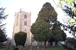
The parish church, St Laurence is a mediæval edifice and a Grade I listed building. It has features from the 12th to the 20th century.
The Primitive Methodist Chapel was built on land donated by Revd W.Sturtevant in 1827. In 1843 this chapel was bought by the Wesleyans, who re-opened it on 6 November. This flourished and was enlarged in 1909, with a school room built by Henry Clipsham & Sons at a cost of £337. It became a private house in 1991.
About the village
The Pinfold
The village pinfold or pound is located on Bathley Lane (west side) close to its junction with Main Street and Woodhouse Road. The 18th century circular structure is of brick with half round ashlar copings with a pair of square gate pillars with ashlar capitals. The wooden gate is 20th century. The pinfold is approximately thirty feet in diameter and is reputedly the largest round pinfold in Nottinghamshire.
The structure is a Grade II listed building.[2]
Windmill
A tower windmill stands in Main Street, and a date stone suggests that it was built in 1852. It is a five-storey brick tower, standing 43 feet high to the curb, with Yorkshire sliding windows. There were three pairs of millstones on the first floor, overdriven by a wooden upright shaft in wooden bearings.
The mill had four sails which used the Cubitt patent system of a striking lever to the rear so that the shutters could be furled by only removing the weight from the chain to the striking lever. It was winded by a fantail which served to turn the main sails of the mill automatically into the wind.
A 1910 description, which was part of a national survey to establish a new property tax, states that the Mill House was in good repair, with two living rooms, kitchen, dairy, and three bedrooms. Outside there was a coal house, an outside privy, a stable (with two stalls), chaff house, cart shed, bake house, engine shed (wood, iron), and a mill powered by steam and wind in good repair. The whole property was assessed at a market value of £480 of which buildings accounted for £420.
Plans to restore the Tower Mill have failed and Planning permission has been granted to convert the building into a dwelling integrated into the existing 1970's bungalow alongside.
Outside links
| ("Wikimedia Commons" has material about Norwell, Nottinghamshire) |
References
- ↑ Ekwall, Eilert, The Concise Oxford Dictionary of English Place-Names. Oxford, Oxford University Press, 4th edition, 1960. p. 345 ISBN 0198691033
- ↑ National Heritage List 1045950: Norwell Village Pound (Grade II listing)


