Difference between revisions of "North East Liberties of Coleraine"
m |
|||
| Line 6: | Line 6: | ||
The Liberties were lands formerly belonging to Antrim, but were granted by King James I to the Honourable the Irish Society and its new [[County Londonderry|County of Londonderry]] in order that the company should have control of the mouth of the [[River Bann]]. Likewise the lands west of the mouth of the [[River Foyle]] were granted as the [[North West Liberties of Londonderry]]. | The Liberties were lands formerly belonging to Antrim, but were granted by King James I to the Honourable the Irish Society and its new [[County Londonderry|County of Londonderry]] in order that the company should have control of the mouth of the [[River Bann]]. Likewise the lands west of the mouth of the [[River Foyle]] were granted as the [[North West Liberties of Londonderry]]. | ||
| − | The North East Liberties of Coleraine have the status of a Barony of [[County Londonderry]].<ref name="PRONI"/> The Liberties border the northern County Londonderry coastline, and are bordered by three other baronies: [[Barony of Coleraine|Coleraine]] to the west and the [[County Antrim|Antrim]] baronies of [[Dunluce Lower]] to the | + | The North East Liberties of Coleraine have the status of a Barony of [[County Londonderry]].<ref name="PRONI"/> The Liberties border the northern County Londonderry coastline, and are bordered by three other baronies: [[Barony of Coleraine|Coleraine]] to the west and the [[County Antrim|Antrim]] baronies of [[Dunluce Lower]] to the north-east and [[Dunluce Upper]] to the south-east.<ref name="PRONI"/> |
| − | The North East Liberties formed the north-western part of the | + | The North East Liberties formed the north-western part of the mediæval territory known as ''The Route''. |
==Towns== | ==Towns== | ||
| Line 15: | Line 15: | ||
*[[Portstewart]] | *[[Portstewart]] | ||
| − | == | + | ==Parishes== |
| − | The | + | The parishes in the North East Liberties of Coleraine are:<ref name="Billmacafee"/> |
{| | {| | ||
Revision as of 18:06, 9 November 2015
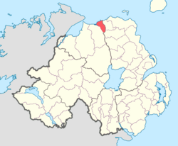
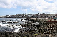
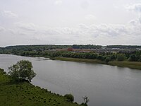
The North East Liberties of Coleraine are the parts of County Londonderry to the east of the River Bann. They are named after Coleraine town, and today much of that town has extended into its liberties. The one other town in the Liberties is Portstewart, a jolly seaside resort town.
The Liberties were lands formerly belonging to Antrim, but were granted by King James I to the Honourable the Irish Society and its new County of Londonderry in order that the company should have control of the mouth of the River Bann. Likewise the lands west of the mouth of the River Foyle were granted as the North West Liberties of Londonderry.
The North East Liberties of Coleraine have the status of a Barony of County Londonderry.[1] The Liberties border the northern County Londonderry coastline, and are bordered by three other baronies: Coleraine to the west and the Antrim baronies of Dunluce Lower to the north-east and Dunluce Upper to the south-east.[1]
The North East Liberties formed the north-western part of the mediæval territory known as The Route.
Towns
- Coleraine (east of the River Bann)
- Portstewart
Parishes
The parishes in the North East Liberties of Coleraine are:[2]
|
|


