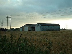
Nibley
From Wikishire
Revision as of 20:34, 30 March 2015 by RB (Talk | contribs) (Created page with "{{Infobox town |name=Nibley |county=Gloucestershire |picture=Nibley - geograph.org.uk - 33662.jpg |picture caption=Farm buildings at Nibley |os grid ref=ST692822 |latitude=51....")
| Nibley | |
| Gloucestershire | |
|---|---|
 Farm buildings at Nibley | |
| Location | |
| Grid reference: | ST692822 |
| Location: | 51°32’22"N, 2°26’40"W |
| Data | |
| Local Government | |
| Council: | South Gloucestershire |
Nibley is a village in the Parish of Westerleigh in Gloucestershire, just west of Yate and to some extent merging into it.
The larger village of North Nibley (also commonly known as Nibley) is some 10 miles away to the north, and there is also a Nibley on the west bank of the Severn, near Lydney.
This Gloucestershire article is a stub: help to improve Wikishire by building it up.