Newcastle, Shropshire
| Newcastle | |
| Shropshire | |
|---|---|
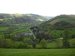
 A view over the village of Newcastle taken from the Offa's Dyke Path | |
| Location | |
| Grid reference: | SO247823 |
| Location: | 52°26’2"N, 3°6’25"W |
| Data | |
| Population: | 319 (2011[1]) |
| Post town: | Craven Arms |
| Postcode: | SY7 |
| Dialling code: | 01588 |
| Local Government | |
| Council: | Shropshire |
| Parliamentary constituency: |
Ludlow |
Newcastle is a village in the rural south-west of Shropshire. It lies at the confluence of the River Clun and the Folly Brook, three miles west of the small town of Clun. The B4368 runs through the village, on its way between Craven Arms in Shropshire to Newtown in Montgomeryshire.
The village has a community hall, a campsite (Clun Valley Camping), a church and a pub (the "Crown Inn").[2]
Newcastle A.F.C.
An association football club exists in the village, called Newcastle A.F.C., whose home ground is the Mill Field, situated to the south-west of the village between the B-road and the Folly Brook.[3] They play in the Mid Wales South League[4] and were the League Champions in the 2011-12 season.[5] Another Shropshire village, also in the south-west of the county, have a team playing in the same league: Bucknell.
The parish
The civil parish is called 'Newcastle on Clun'.[6] It covers the village and surrounding countryside, reaching the border with Montgomeryshire to the north. It is part of the remote and very rural Clun Forest, part of the Shropshire Hills Area of Outstanding Natural Beauty. Offa's Dyke and Offa's Dyke Path run through the area.
Church
The Church of England parish church, dedicated to St John the Evangelist, was built by Shrewsbury architect Edward Haycock, Sr in 1848. As a memorial to the First World War, electric lighting was installed in the building.[7] The churchyard contains war graves of a soldier of World War I and another of World War II.[8]
References
- ↑ "Civil Parish population 2011". http://www.neighbourhood.statistics.gov.uk/dissemination/LeadKeyFigures.do?a=7&b=11126908&c=SY7+8QL&d=16&e=62&g=6461068&i=1001x1003x1032x1004&m=0&r=0&s=1448797313001&enc=1. Retrieved 29 November 2015.
- ↑ "The Crown at Newcastle". http://www.crown-newcastle.com. Retrieved 1 February 2008.
- ↑ Google Maps Mill Ground
- ↑ Mid Wales South League official website
- ↑ Mid Wales South League 2011-12 League Champions
- ↑ "Newcastle Parish Council". http://www.newcastleparishcouncil.org.uk. Retrieved 2 October 2008.
- ↑ Francis, Peter (2013). Shropshire War Memorials, Sites of Remembrance. YouCaxton Publications. p. 93. ISBN 978-1-909644-11-3.
- ↑ [1] CWGC Cemetery report, detail from casualty record.
Outside links
| ("Wikimedia Commons" has material about Newcastle, Shropshire) |