New Luce
| New Luce | |
| Wigtownshire | |
|---|---|

| |
| Location | |
| Location: | 54°56’38"N, 4°51’7"W |
| Data | |
| Population: | 137 (2011) |
| Post town: | Newton Stewart |
| Postcode: | DG8 |
| Dialling code: | 01581 |
| Local Government | |
| Council: | Dumfries and Galloway |
| Parliamentary constituency: |
Dumfries and Galloway |
New Luce is a small village and parish in Wigtownshire.
The parish of New Luce, of which New Luce is the principal and indeed only village, is 10 miles in length and five miles wide, being the upper part of the original Glenluce Parish.[1] New Luce is shown as a civil parish on John Ainslie's county map of 1782.[2]
The coast to coast walk, the Southern Upland Way, passes close to the village.[3] The Covenanter Alexander Peden spent time preaching in the village.
Places of interest
A viaduct carried the Stranraer-Glasgow railway over the Main Water of Luce. Down the river from the viaduct is a pool called Bloody Wheel where the Hays of Castle of Park, near Glenluce (Old Luce), and the Linns of Larg in the adjoining parish of Inch, were said to have had a violent encounter centuries ago.[4][5]
Archaeology
The Caves of Kilhern, between 2,000 and 3,000 years old, are in south New Luce.
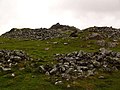
Cairn na Gath ("cairn of the wild cat"), near Balmurrie, is a chambered long cairn dating to the neolithic (later stone-age). At the south end there are remains of huts or enclosures.[6]
Cairn Macneilie, 100 yards north-west of Cruise, New Luce, is a Bronze Age round cairn, 56 feet in diameter and 3 feet 6" high.[7][8] There is another Cairn Macneilie at Inch Parks, by Lochinch Castle in Inch Parish. They may have been named after a person who conducted archaeological excavations.
Forts
Rev. George Wilson, in his Archaeological and Historical Collections relating to Ayrshire and Galloway, lists forts in New Luce:[9]
- Cruise Back Fell, fort marked on the map as two cairns, 80 ft long, on the Fell of Cruise or High Galdenoch.[10]
- Gleniron Several fort with a cluster of green rings, and a large ditch and mote.[11][12]
- Mid Gleniron [13]
- Mid Gleniron tomb, where the long cairn had enclosed an earlier smaller one.[14]
- Garvilland Iron-age hill fort on the Bennan, double at the one end and with hut circles.[15]
- Klashherne, two rings, and three more, not on O.S. map.[16]
- Balmurrie, ring with two hut circles.
Picture
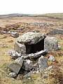
'Caves' of Kilhern: six neolithic chambered cairns, estimated at between 2,000–3,000 years old
Cairn na Gath, near Balmurrie
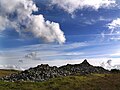
Cairn na Gath. This is a chambered long cairn dating to the neolithic
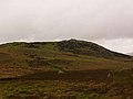
Bennan of Garvilland Iron Age hill fort
Bennan of Garvilland hill fort - entrance
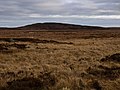
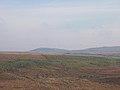
Bught Fell and Kilhern Moss
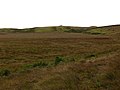
Looking across open moorland to the cairn on Cairn Park, behind Glenchamber
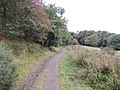
Southern Upland Way near Cairn Macneilie, Cruise
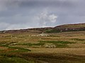
A windfarm at Artfield Fell, east of New Luce
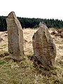
Laggangairn Standing Stones
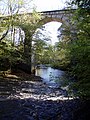
Viaduct over Main Water of Luce


| ("Wikimedia Commons" has material about New Luce) |
References
- ↑ http://www.dgcommunity.net/communitycouncil/default.aspx?id=56
- ↑ "View: A map of the county of Wigton. - Counties of Scotland, 1580-1928 - National Library of Scotland". Maps.nls.uk. http://maps.nls.uk/counties/view/?id=685. Retrieved 2012-09-09.
- ↑ http://www.newlucehistory.co.uk/
- ↑ National Archives of Scotland GD72/142(i). 13 May 1662. Bond by Sir Thomas HAY, younger of (Castle of) Park, and William LIN of Large, as cautioners to William GORDON of Craiglaw
- ↑ National Archives of Scotland. GD135/798, 800, 804, 955. c.1687
- ↑ http://www.explorebritain.info/antiquity-dumfries-and-galloway-cairn-na-gath-nx2167
- ↑ http://www.megalithic.co.uk/modules.php?op=modload&name=a312&file=index&do=showpic&pid=9711
- ↑ http://canmore.rcahms.gov.uk/en/site/61666/details/cruise+cairn+macneilie/
- ↑ Archaeological and Historical Collections relating to Ayrshire and Galloway. vol.V. pp.63-64 http://archive.org/stream/cu31924092901606#page/n115/mode/2up
- ↑ http://www.scotlandsplaces.gov.uk/search_item/index.php?service=RCAHMS&id=61644
- ↑ http://www.scotlandsplaces.gov.uk/search_item/index.php?service=RCAHMS&id=61598
- ↑ http://www.themodernantiquarian.com/site/5620/
- ↑ http://www.scotlandsplaces.gov.uk/search_item/index.php?service=RCAHMS&id=61594
- ↑ Discovery and Excavation 1963, 51ff ; Corcoran. 1964 http://www.dgnhas.org.uk/
- ↑ http://www.scotlandsplaces.gov.uk/search_item/index.php?service=RCAHMS&id=61599
- ↑ http://canmore.rcahms.gov.uk/en/site/62443/details/bught+fell/