Naseby
| Naseby | |
| Northamptonshire | |
|---|---|

| |
| Location | |
| Grid reference: | SP689781 |
| Location: | 52°23’49"N, 0°59’18"W |
| Data | |
| Population: | 687 (2011) |
| Post town: | Northampton |
| Postcode: | NN6 |
| Dialling code: | 01604 |
| Local Government | |
| Council: | West Northamptonshire |
| Parliamentary constituency: |
Daventry |
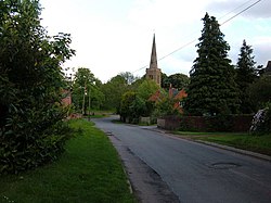
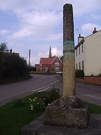
Naseby is a village in Northamptonshire. The village is fourteen miles north of Northampton, thirteen miles north-east of Daventry, and seven miles south of Market Harborough.
The population of the civil parish at the 2011 Census was 687.
The village sits in a commanding position on one of the highest parts of the Northamptonshire Uplands, close to the county border with Leicestershire.
Contents
Name
The name of the village has two suggested origins: most likely it is from the Old English Hnæfes burh, meaning 'Hnæf's fortified place' after an otherwise unknown local lord, taking advantage of the village's strategic location.
Another suggestion derives the name from the Old English næfela, meaning navel, because it was thought to be the navel of England, or of the county, being the source of several rivers flowing out in different directions.
The name is recorded in the Domesday Book as Navesberie. In later records the village had been known as Navesby and Nathesby.
History
Early history
An Anglo-Saxon trefoil-headed brooch was found in the village in the 19th-century discovery, which is now in the collection of the British Museum.
In 1086 Naseby appeared in the Domesday Book.
In 1203, King John granted Naseby its market charter and the village became a flourishing market town for many years. During this period the village grew. In 1349, the Black Death attacked the village and greatly reduced its population, with parts becoming abandoned altogether. Extensive earthworks in the fields adjacent to parts of the village show the outlines of lost lanes and the outlines of buildings and enclosures which existed before the Black Death.
Battle of Naseby
The Battle of Naseby took place on 14 June 1645, during the Civil War. In the area called Broad Moor a small distance north of the village, the Royalist forces, commanded by King Charles I, battled the Roundhead army commanded by Thomas Fairfax, 3rd Lord Fairfax of Cameron. The battle resulted in a decisive Royalist defeat.
A naval warship during the Commonwealth period was named the Naseby in honour of the battle; after the Restoration the ship was renamed Royal Charles.
Modernity
During the 18th century, Naseby continued as an agricultural community and during this time several fine Georgian buildings were constructed in the parish.). One of the most significant buildings is Naseby House, built in 1818 for the Fitzgeralds, Lords of the Manor. Naseby Hall, altered by E F Law in 1859 was badly damaged by fire in 1948, and was rebuilt from the ground up using the old materials.[1]
In 1822 the Enclosure commissioners allocated the open land around the village to two landowners, who duly fenced off their newly acquired fields.
Until around 1870, most buildings (except for the church, chapel, school, and the three houses from the Georgian period) were made of mud walls and cob with thatched roofs. During the 1870s Lord Clifden had most of the cottages demolished and replaced with new red-brick cottages, some of which were semi-detached, to house his estate workers. This gave Naseby its well-known Victorian appearance. All these Victorian houses still survive to this day, along with two remaining 17th-century cob-and-thatch cottages.
Churches
The two churches in Naseby are:
- Church of England: All Saints' Church, which is a Grade II* listed building
- Methodist: Naseby Methodist Church[2]
River sources
Naseby and the plateau of land towards Sibbertoft form a watershed and contain the sources of four rivers flowing west, south and east:
- The River Avon (the Warwickshire Avon), in the front garden of Manor Farm
- The northern tributary of the River Nene (Brampton Arm), rising by the Thornby road west of the village, the main Source being at Arbury Hill (SP542581), the county top;
- The River Ise, close to Sibbertoft Road to the north of Naseby.
- The River Welland, in fields close to Welland Rise, Sibbertoft village, three miles to the north.
Outside links
| ("Wikimedia Commons" has material about Naseby) |
References
- ↑ Nikolaus Pevsner: The Buildings of England: Northamptonshire, 1961; 1973 Penguin Books ISBN 978-0-300-09632-3page 309
- ↑ Naseby Methodist Church
- Crowley, A.J. and Westaway, E.H.: 'Naseby - A short guide to the village and its history'


