Difference between revisions of "Muthill"
(Created page with "{{Infobox town |county=Perthshire |gaelic=Maothail |picture=Muthill.jpg |picture caption= |census date= |os grid ref=NN867168 |latitude=56.32998 |longitude=-3.83395 |populati...") |
|||
| Line 16: | Line 16: | ||
|website= | |website= | ||
}} | }} | ||
| − | '''Muthill''' | + | '''Muthill''' is a village and parish in [[Perthshire]]. It lies just west of the former railway line connecting [[Gleneagles]] and [[Crieff]], three miles south of Crieff. The line closed between the two points on 6 July 1964. The name possibly derives from Moot hill, a place of judgement.<ref name="Knight">Knight, James. ''Glasgow and Strathclyde''. London : Thomas Nelson & Sons. p. 87.</ref> |
The ancient village was once an important religious centre and the site of a Celí Dé monastery. The church here also served for a time as a seat of the Bishops of Strathearn (later [[Dunblane]]) before the building of the cathedral at Dunblane in the 13th century. | The ancient village was once an important religious centre and the site of a Celí Dé monastery. The church here also served for a time as a seat of the Bishops of Strathearn (later [[Dunblane]]) before the building of the cathedral at Dunblane in the 13th century. | ||
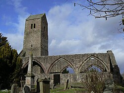
| − | [[File:Muthill old church - geograph.org.uk - 1189328.jpg|thumb|left|Ruined mediæval Church at Muthill]] | + | [[File:Muthill old church - geograph.org.uk - 1189328.jpg|thumb|left|250px|Ruined mediæval Church at Muthill]] |
The village was largely destroyed in the 1715 – 1716 Jacobite rising, by Jacobite troops retiring after their defeat at the Battle of Sheriffmuir, being rebuilt in the 1740s as it lay on the route of General Wade's military road through Strathearn. | The village was largely destroyed in the 1715 – 1716 Jacobite rising, by Jacobite troops retiring after their defeat at the Battle of Sheriffmuir, being rebuilt in the 1740s as it lay on the route of General Wade's military road through Strathearn. | ||
| − | [[File:Bronze Armlet (2).JPG|thumb|left|One of a pair of massive brass armlets found at Pitkelloney Farm near Muthill and dating from 50-200 | + | [[File:Bronze Armlet (2).JPG|thumb|left|250px|One of a pair of massive brass armlets found at Pitkelloney Farm near Muthill and dating from AD 50-200 ([[British Museum]])<ref>British Museum Highlights [http://www.britishmuseum.org/explore/highlights/highlight_objects/pe_prb/m/massive_brass_armlet.aspx]</ref>]] |
There are over a hundred listed buildings in the village. The kirkyard at the centre of the small town contains the ruins of an important 15th-century parish church, which incorporates an 11th-century bell-tower (originally free-standing, and comparable to, though on a smaller scale than, that incorporated into [[Dunblane Cathedral]]), built on the orders of Michael Ochiltree, [[Bishop of Dunblane]] (in the care of [[Historic Scotland]]; no entrance charge). This is almost the only visible reminder of the ancient village. An early Christian cross-slab (perhaps 10th-11th century) and a damaged 13th-century double effigy of an Earl and Countess of Strathearn (formerly within the choir of the church) are preserved within the tower. | There are over a hundred listed buildings in the village. The kirkyard at the centre of the small town contains the ruins of an important 15th-century parish church, which incorporates an 11th-century bell-tower (originally free-standing, and comparable to, though on a smaller scale than, that incorporated into [[Dunblane Cathedral]]), built on the orders of Michael Ochiltree, [[Bishop of Dunblane]] (in the care of [[Historic Scotland]]; no entrance charge). This is almost the only visible reminder of the ancient village. An early Christian cross-slab (perhaps 10th-11th century) and a damaged 13th-century double effigy of an Earl and Countess of Strathearn (formerly within the choir of the church) are preserved within the tower. | ||
Latest revision as of 10:19, 17 April 2019
| Muthill Gaelic: Maothail | |
| Perthshire | |
|---|---|

| |
| Location | |
| Grid reference: | NN867168 |
| Location: | 56°19’48"N, 3°50’2"W |
| Data | |
| Population: | 675 |
| Post town: | Crieff |
| Postcode: | PH5 |
| Dialling code: | 01764 |
| Local Government | |
| Council: | Perth and Kinross |
| Parliamentary constituency: |
Ochil and South Perthshire |
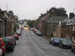
Muthill is a village and parish in Perthshire. It lies just west of the former railway line connecting Gleneagles and Crieff, three miles south of Crieff. The line closed between the two points on 6 July 1964. The name possibly derives from Moot hill, a place of judgement.[1]
The ancient village was once an important religious centre and the site of a Celí Dé monastery. The church here also served for a time as a seat of the Bishops of Strathearn (later Dunblane) before the building of the cathedral at Dunblane in the 13th century.
The village was largely destroyed in the 1715 – 1716 Jacobite rising, by Jacobite troops retiring after their defeat at the Battle of Sheriffmuir, being rebuilt in the 1740s as it lay on the route of General Wade's military road through Strathearn.

There are over a hundred listed buildings in the village. The kirkyard at the centre of the small town contains the ruins of an important 15th-century parish church, which incorporates an 11th-century bell-tower (originally free-standing, and comparable to, though on a smaller scale than, that incorporated into Dunblane Cathedral), built on the orders of Michael Ochiltree, Bishop of Dunblane (in the care of Historic Scotland; no entrance charge). This is almost the only visible reminder of the ancient village. An early Christian cross-slab (perhaps 10th-11th century) and a damaged 13th-century double effigy of an Earl and Countess of Strathearn (formerly within the choir of the church) are preserved within the tower.
Muthill Primary School serves the village. There is no secondary school.
In 2011, Muthill embarked upon a Community Action Plan exercise to explore how people envisaged the development of the village.[3]
References
- ↑ Knight, James. Glasgow and Strathclyde. London : Thomas Nelson & Sons. p. 87.
- ↑ British Museum Highlights [1]
- ↑ Duke, Lynn (18 March 2011), "Muthill looks forward to new action plan", Strathearn Herald, http://www.strathearnherald.co.uk/strathearn-news/strathearn-news/2011/03/18/muthill-looks-forward-to-new-action-plan-64054-28349198/, retrieved 16 August 2011
Outside links
| ("Wikimedia Commons" has material about Muthill) |
This Perthshire article is a stub: help to improve Wikishire by building it up.
