Mugdrum
| Mugdrum | |
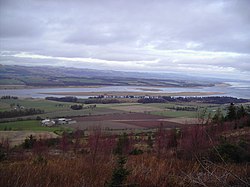
 Mugdrum seen from Carpow Hill, Fife | |
|---|---|
| Location | |
| Location: | 56°21’22"N, 3°15’21"W |
| Grid reference: | NO225189 |
| Area: | 79 acres |
| Highest point: | 13 ft |
| Data | |
| Population: | nil |
Mugdrum Island lies in the Firth of Tay, offshore from the town of Newburgh, Fife, but belonging to Perthshire.[1]
Contents
Geography
Mugdrum is low-lying and reedy, with the "North Deep" and "South Deep" channels on either side of the island. It covers an area of 32 acres.[1]
History
Mugdrum's name is from muc-dhruim, the Gaelic for hog-back. However, this was applied to the coast opposite, which part it was named for.[1]
The reeds were once harvested for thatching and for protecting potatoes during transshipment. Until 1926, a 50-acre farm grew cereals, potatoes and turnips in the island's alluvial soil. It is now a nature reserve under the stewardship of the Tay Valley Wildfowlers' Association.
The Laing Museum in Newburgh preserves the stuffed body of a two-headed kitten born in the 19th century on Mugdrum.
References
- ↑ 1.0 1.1 1.2 "Historical perspective for Mugdrum Island". Gazetteer for Scotland. http://www.scottish-places.info/features/featurehistory1607.html. Retrieved 2008-10-05.
Outside links
| ("Wikimedia Commons" has material about Mugdrum) |
This Perthshire article is a stub: help to improve Wikishire by building it up.