Muasdale
From Wikishire
| Muasdale Gaelic: Muasdal | |
| Argyllshire | |
|---|---|
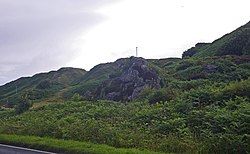
 Rock outcrops near Muasdale | |
| Location | |
| Grid reference: | NR679402 |
| Location: | 55°36’0"N, 5°41’5"W |
| Data | |
| Local Government | |
| Council: | Argyll and Bute |
| Parliamentary constituency: |
Argyll and Bute |
Muasdale is a hamlet on the western coast of Kintyre, the long, pendulous peninsula of Argyllshire. As of the year 2000 Muasdale had a population of 300.[1]
By the year 1750 acording to the William Roy map, there was a coastal track along the west coast of Kintyre, even though the population level of the entire southern peninsula was very low.
| ("Wikimedia Commons" has material about Muasdale) |
References
- ↑ Robin Smith and Alan Lawson. 2000
- Smith, Robin and Lawson, Alan: 'The making of Scotland: a comprehensive guide to the growth of its cities' (2000)