Difference between revisions of "Moylussa"
From Wikishire
(Created page with '{{Infobox hill |name=Moylussa |county=Clare |picture= |os grid ref= R64837593 |height=1,745 feet }} '''Moylussa''' is a mountain overlooking the River Shannon in [[County Cla…') |
|||
| Line 2: | Line 2: | ||
|name=Moylussa | |name=Moylussa | ||
|county=Clare | |county=Clare | ||
| − | |picture= | + | |picture=Killaloe, County Clare with the Shannon in the foreground.jpg |
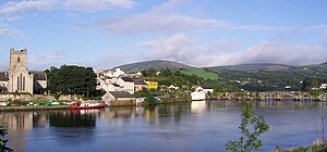
| + | |picture caption=Moylussa behind Killaloe, County Clare | ||
|os grid ref= R64837593 | |os grid ref= R64837593 | ||
|height=1,745 feet | |height=1,745 feet | ||
Revision as of 13:55, 17 January 2018
| Moylussa | |
| County Clare | |
|---|---|
 Moylussa behind Killaloe, County Clare | |
| Summit: | 1,745 feet R64837593 |
Moylussa is a mountain overlooking the River Shannon in County Clare. Its summit is at 1,745 feet above sea level: the highest point in the county and thus Clare's county top.
It is a boggy mountain, not a pleasant climb by all accounts, but popular for all that. A favoured route for the climb is to start at Killaloe, from where a path leads up through the forest. Another is to top the mountain after climbing Glenvagalliagh.
The East Clare Way climbs Moylussa and provides yet another route, from the Ballycuggaran Forest.
References
This Mountain or hill article is a stub: help to improve Wikishire by building it up.