Monksilver
| Monksilver | |
| Somerset | |
|---|---|
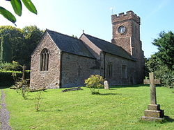
 Church of All Saints, Monksilver | |
| Location | |
| Grid reference: | ST072378 |
| Location: | 51°7’56"N, 3°19’37"W |
| Data | |
| Population: | 113 (2011) |
| Post town: | Taunton |
| Postcode: | TA4 |
| Dialling code: | 01984 |
| Local Government | |
| Council: | Somerset West and Taunton |
| Parliamentary constituency: |
Bridgwater & W. Somerset |
Monksilver is a village in Somerset three miles west of Williton, on the eastern flank of the Brendon Hills.
The Exmoor National Park spreads out to the west of the village. The Coleridge Way footpath passes though the village.
History
In the Domesday Book of 1086 the manor is named as Selvre, which is said to be from the Latin silva, meaning 'wood',[1] though Latin names are very rare before the monastic inventions that came with the Norman Conquest so this seems doubtful. Another suggestion is that Sulfhere, recorded in AD 897, refers to the silvery stream below the village.[2] We can never know.
In 1113 the manor was given by Robert de Chandos to endow Goldcliff Priory, which he had just established near Newport in Monmouthshire . In 1441 it passed, with the priory, to Tewkesbury Abbey and then in 1474 to the canons of Windsor.[2] In the 14th century the name changed to "Monksilver".[3]
In the 16th and 17th centuries, Monksilver was a centre for cloth making[2] and field names such as "Rack", at nearby Woodford, suggest this activity.[3]
Parish church
The parish church, dedicated to All Saints, has a square tower containing five bells. Inside is a rare Easter sepulchre. It has a wagon roof, thought to be of the 13th-century.
The pulpit is of the 16th-century, the screen is Jacobean and the lectern is possibly older. An alms box stands by the door, from 1634.
The church today has been designated as a Grade I listed building.[4]
This is the church where in 1583 Sir Francis Drake married his second wife Elizabeth Sydenham, of nearby Combe Sydenham in the parish of Stogumber.[2]
Amenities
The village has a village hall (shared with the parishes of Nettlecombe and Elworthy), a telephone box and a newspaper hut. The village pub, The Notley Arms, serves locally sourced food.[5] The village is served twice a week with a bus service connecting it to Taunton. The mobile library visits every three weeks.
The village lies on the route of both the Coleridge Way and Samaritans Way South West.[6]
Outside links
| ("Wikimedia Commons" has material about Monksilver) |
References
- ↑ Robinson, Stephen (1992). Somerset Place Names. Wimborne, Dorset: Dovecote Press. ISBN 1-874336-03-2.
- ↑ 2.0 2.1 2.2 2.3 Bush, Robin (1994). Somerset: The complete guide. Wimborne: The Dovecote Press Ltd. pp. 148–149. ISBN 1-874336-26-1.
- ↑ 3.0 3.1 A History of the County of Somerset - Volume 5 : {{{2}}} (Victoria County History) – [1]
- ↑ Images of England — details from listed building database (264774) Church of All Saints
- ↑ "The Notley Arms". Archived from the original on 12 November 2011. https://web.archive.org/web/20111112162414/http://www.exmoorblog.org.uk/2010/03/the-notley-arms-monksilver/. Retrieved 30 March 2010.
- ↑ "Samaritans Way". Bristol Ramblers. http://www.bristolramblers.org.uk/walks2/routes-to-walk/samaritans-way.html. Retrieved 27 October 2015.