Melbury Bubb
| Melbury Bubb | |
| Dorset | |
|---|---|
 St Mary, Melbury Bubb | |
| Location | |
| Grid reference: | ST596065 |
| Location: | 50°51’26"N, 2°34’31"W |
| Data | |
| Population: | 40 (est.) |
| Local Government | |
| Council: | Dorset |
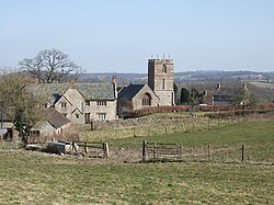
Melbury Bubb is a small village in Dorset, found about seven miles south of Sherborne.
The village is in the vale beneath the chalk hills of the Dorset Downs, sited on Cornbrash limestone[1]. The A37 trunk road between Dorchester and Bristol passes about half a mile to the west, on the other side of Bubb Down Hill. This hill used to be the site of a beacon.
The first half of the village’s name derives from the Old English mæle burg, meaning "multi-coloured fortified place". The second element of the name, Bubb, is a manorial name which derives either from an Anglo-Saxon named 'Bubba' or from mediæval lords of the manor. A 2013 estimate put the parish population at 40.
The parish church, St Mary, has a 15th-century tower but the rest of the building was largely rebuilt in a 19th-century restoration. Its font however is carved out of the column of an upturned Saxon cross; it is elaborately carved, although the carvings are upside-down.[2]
Outside links
| ("Wikimedia Commons" has material about Melbury Bubb) |
References
- ↑ Ralph Wightman (1983). Portrait of Dorset (4 ed.). Robert Hale Ltd. p. 18. ISBN 0 7090 0844 9.
- ↑ Roland Gant (1980). Dorset Villages. Robert Hale Ltd. p. 69. ISBN 0 7091 8135 3.
