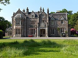
Meiklewood House
From Wikishire
Revision as of 20:43, 19 January 2021 by RB (Talk | contribs) (Created page with "{{Infobox house |name=Meiklewood House |county=Stirlingshire |picture=Meiklewood House - geograph.org.uk - 184249.jpg |picture caption=Meiklewood House |os grid ref=NS72769562...")
| Meiklewood House | |
| Stirlingshire | |
|---|---|
 Meiklewood House | |
| Location | |
| Grid reference: | NS72769562 |
| Location: | 56°8’11"N, 4°2’56"W |
| History | |
| Country house | |
| Information | |
Meiklewood House is a country house with farm in the north of in Stirlingshire, to the north-east of Gargunnock. The house is found in a tight loop of an upper reach of the River Forth and is, as the name suggests, concealed in woodland. The house is a Category B listed building.[1]
The river here forms the border with Perthshire to the north. An estate bridge, the Meiklewood House Bridge, crosses the river to Easter Ross Farm.
References
- ↑ Meiklewood House, Gargunnock - British Listed Buildings
This Stirlingshire article is a stub: help to improve Wikishire by building it up.