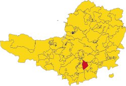
Martock Hundred
Martock Hundred is one of the hundreds in Somerset. It is situated towards the south-east of the county, and is bounded to the north by Somerton Hundred; to the east by Tintinhull Hundred; to the south by South Petherton Hundred; and to the west by Kingsbury and Pitney Hundreds.
It is conterminous with the ancient parish of Martock.[1] The northern boundary is formed by the River Ivel; and the southern boundary the Fosse Way.[2] It originated in a Royal estate which existed before the Norman conquest.[3]
References
- ↑ "Hundred: Martock". Open Domesday. Archived from the original on 30 July 2012. https://archive.today/20120730021502/http://www.domesdaymap.co.uk/hundred/martock/. Retrieved 23 October 2011.
- ↑ "The Hundred of Martock". Martock Local History Club. http://www.martockhistory.co.uk/joomla15/index.php?option=com_content&view=article&id=11:the-hundred-of-martock&catid=1:martock-general&Itemid=9. Retrieved 23 October 2011.
- ↑ R.W. Dunning (editor), A.P. Baggs, R.J.E. Bush (1978). "Martock Hundred: Introduction". A History of the County of Somerset: Volume 4. Institute of Historical Research. http://www.british-history.ac.uk/report.aspx?compid=117084. Retrieved 23 October 2011.
| Hundreds of Somerset |
|---|
|
Abdick and Bulstone • Andersfield • Bath Forum (inc. Hampton & Claverton liberty) • Bempstone • Brent-cum-Wrington • Bruton • Cannington • Carhampton • Catsash • Chew • Chewton • Crewkerne • Frome • Glaston Twelve Hides • Hartcliffe • Horethorne • Houndsborough • Huntspill and Puriton • Keynsham • Kilmersdon (inc. Mells & Leigh liberty) • Kingsbury • Martock • Milverton • North Curry • North Petherton • Norton Ferris • Pitney • Portbury • Somerton • South Petherton • Stone • Taunton Deane • Tintinhull • Wellow • Wells Forum • Whitley • Whitstone • Williton and Freemanners • Winterstoke |
