Mappowder
| Mappowder | |
| Dorset | |
|---|---|
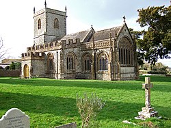
 Parish church of St Peter and St Paul | |
| Location | |
| Grid reference: | ST735061 |
| Location: | 50°51’13"N, 2°22’42"W |
| Data | |
| Population: | 166 |
| Post town: | Sturminster Newton |
| Postcode: | DT10 |
| Local Government | |
| Council: | Dorset |
| Parliamentary constituency: |
North Dorset |
Mappowder is a village in the centre of Dorset, about nine miles south-east of the town of Sherborne.
The parish covers about 1,900 acres,[1] sited on Corallian limestone soil[2] at the southern edge of the Blackmore Vale, close to the northern scarp face of the Dorset Downs. The 2011 census noted that the parish had 71 dwellings, 69 households and a population of 166.
The village name comes from mapuldor, Old English for 'maple tree'.[3] In 1086 in the Domesday Book Mappowder is recorded as Mapledre and appears in four entries; it was in Buckland Newton Hundred, had 33 households and a total taxable value of eight geld units.[4][5]
Parish church
The church, dedicated to St Peter and St Paul, is in the Perpendicular Gothic style. It was built in the late 15th and 16th centuries. However, it includes features remaining from an earlier 12th-century church.
The chancel was expanded in 1868 by the Wingfield Digby family of Sherborne Castle, who owned the village in Victorian times.
Mappowder Court
Mappowder was once the home of the Coker family, who built a large mansion here in 1654,[6] although this was pulled down in the mid-eighteenth century.[7]
The building which occupies the site now, Mappowder Court, is mostly of mid-eighteenth-century origin, with some earlier remnants.[8]
The stone gateposts at the entrance remain from the original Coker manor; these are topped by carved human heads which in 1905 Sir Frederick Treves described as "Blackamore's" these being "those indefinite natives of the tropics having been used for the crest of the Coker family."[6] In 1559 Henry Coker (c.1528–1596) was Member of Parliament for the Borough of Shaftesbury.[9]
Mappowder Court is a Grade II* building.[8] with the gateposts and courtyard walls as Grade II.[10]
Outside links
| ("Wikimedia Commons" has material about Mappowder) |
References
- ↑ Mappowder: An Inventory of the Historical Monuments in Dorset, Volume 3, pages 145-148
- ↑ Wightman, Ralph (1983). Portrait of Dorset (4 ed.). Robert Hale Ltd. p. 17. ISBN 0-7090-0844-9.
- ↑ Gant, p73
- ↑ "Place: Mappowder". Open Domesday. Archived from the original on 2 April 2015. https://web.archive.org/web/20150402140235/http://domesdaymap.co.uk/place/ST7306/mappowder/. Retrieved 28 January 2015.
- ↑ "Dorset H–R". The Domesday Book Online. domesdaybook.co.uk. http://www.domesdaybook.co.uk/dorset2.html. Retrieved 28 January 2015.
- ↑ 6.0 6.1 Treves, Sir F., Highways and Byways in Dorset, Macmillan, 1905, p331
- ↑ Gant, p74
- ↑ 8.0 8.1 National Heritage List 1324499: Mappowder Court
- ↑ "COKER, Henry (c.1528-95), of Mappowder, Dorset". The History of Parliament. British Political, Social and Local History. Crown copyright and The History of Parliament Trust. http://www.historyofparliamentonline.org/volume/1558-1603/member/coker-henry-1528-95. Retrieved 1 February 2015.
- ↑ National Heritage List 1287677: Gate Piers East of Mappowder Court Together with Walls and Piers to North
- Gant, Roland: 'Dorset Villages' (Robert Hale Ltd, 1980) ISBN 0-7091-8135-3