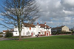
Mangotsfield
From Wikishire
Revision as of 10:38, 10 March 2017 by Owain (Talk | contribs) (Created page with "{{infobox town |county=Gloucester |picture=Mangotsfield Common ^amp, Lamb Inn. - panoramio.jpg |picture caption=Mangotsfield Common and Lamb Inn |latitude=51.48 |longitude=-2....")
| Mangotsfield | |
| Gloucestershire | |
|---|---|
 Mangotsfield Common and Lamb Inn | |
| Location | |
| Grid reference: | ST641780 |
| Location: | 51°28’48"N, 2°29’24"W |
| Data | |
| Population: | 12,439 (2011 (Rural)[1]) |
| Post town: | Bristol |
| Postcode: | BS16 |
| Dialling code: | 0117 |
| Local Government | |
| Council: | South Gloucestershire |
| Parliamentary constituency: |
Kingswood |
Mangotsfield is an ancient parish in Gloucestershire that forms part of the Bristol urban area.
The village was mentioned in the Domesday Book in 1086 as Manegodesfelle,[2] and as Manegodesfeld in 1377.[3]
Sport and leisure
Mangotsfield is the home of Mangotsfield United F.C. and Cleve R.F.C. Rodway Hill is a favourite spot for dog walkers and the starting point of many pigeon races.[4]
Education and schools
There is one secondary school in Mangotsfield: Mangotsfield School (A Specialist College in Engineering and Science).
References
- ↑ "Parish population 2011.Retrieved 19 March 2015". https://neighbourhood.statistics.gov.uk/dissemination/LeadKeyFigures.do?a=7&b=11126275&c=Mangotsfield&d=16&e=62&g=6390599&i=1001x1003x1032x1004&o=362&m=0&r=1&s=1426797114794&enc=1.
- ↑ National Archives Cat Ref: E31/2/1
- ↑ Plea Rolls of the Court of Common Pleas; National Archives; CP40/466. Year 1377; Edward III ; http://aalt.law.uh.edu/AALT4/E3/CP40no466/aCP40no466fronts/IMG_0047.htm; third entry. the (smudged) first word in the second line & also in the third line
- ↑ http://www.rpra.org/lib_sites.htm