Difference between revisions of "Mangerton, Dorset"
From Wikishire
(Created page with "{{Infobox town |name=Mangerton |county=Dorset |picture=Mangerton Mill.jpg |picture caption=Mangerton Mill |os grid ref=SY488957 |latitude=50.759295 |longitude=-2.726356 |postc...") |
(No difference)
|
Latest revision as of 13:04, 6 July 2020
| Mangerton | |
| Dorset | |
|---|---|
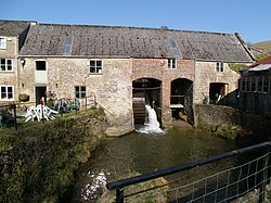
 Mangerton Mill | |
| Location | |
| Grid reference: | SY488957 |
| Location: | 50°45’33"N, 2°43’35"W |
| Data | |
| Local Government | |
| Council: | Dorset |
Mangerton is a hamlet in the west of Dorset, to the north of Bridport. It is on the Mangerton River, which joins the River Asker at Bradpole a little to the south.
Its best-known building is a mill on the river; Mangerton Mill.
Mangerton Mill
Mangerton Mill is a an early 19th century flour-mill on the Mangerton River, though with parts form the 17th century. It was driven by the river, but last worked commercially in 1966. Today it serves as tea shop.
The mill is a Grade II listed building.[1] It is built with rubble-stone walls, and brick at the right hand end, with two segmental arches: the left segmental arch opening contains the water-wheel, an overshot wheel driving machinery in left-hand part. The machinery is mainly intact.
Outside links
| ("Wikimedia Commons" has material about Mangerton, Dorset) |
- Mangerton Mill: Society for the Protection of Ancient Buildings
References
- ↑ National Heritage List 1215867: Mangerton Mill