Manea
| Manea | |
| Cambridgeshire | |
|---|---|
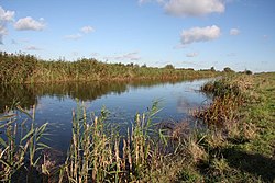
 Counter Wash by Manea | |
| Location | |
| Grid reference: | TL479894 |
| Location: | 52°28’60"N, 0°10’39"E |
| Data | |
| Post town: | March |
| Postcode: | PE15 |
| Local Government | |
| Council: | Fenland |
Manea is a village in Cambridgeshire, in the north of the county and the heart of the Great Fen's table-flat landscape. The name is pronounced with the first syllable as "mane". It stands just to the west of the Old Bedford River and the Hundred Foot Washes which lie between the Old River and the New. There is no road bridge across the rivers here; the nearest crossings are at Welney 7½ miles to the north and Mepal, 17 miles to the south, by road.
The village is not as isolated as the landscape may suggest as Manea has a railway station and is an expanding village. The RSPB's Welches Dam nature reserve is here on the Ouse Washes.[1]
The area has been inhabited for centuries, and Stonea Camp, an Iron Age hill fort is located approximately a mile west of the village.
History
Manea was once a hamlet in the parish of Coveney, and in the seventeenth century Manea was one of the sites where King Charles I was planning to build a new town on drained fenland, to be called Charlemont.[2] The village's parish church is dedicated to St Nicholas and was built in 1875 to replace an earlier building dating from 1791.[3]
Big Society
The village has a brass band, Manea Silver Band, founded in 1882, which meets for practices in Manea Methodist Chapel. It has a men's football team, who compete in local leagues and cup competitions.
Outside links
| ("Wikimedia Commons" has material about Manea) |
- Manea Parish Council
- Manea Connect, village website
- Manea village history
References
- ↑ RSPB reserves guide: Ouse Washes
- ↑ N. Walker & T. Craddock, The History of Wisbech and the Fens. R. Walker, 1849, page 139.
- ↑ Information on Manea from GENUKI
