Lulsgate Bottom
From Wikishire
Revision as of 13:50, 3 April 2020 by RB (Talk | contribs) (Created page with "{{Infobox town |name=Lulsgate Bottom |county=Somerset |picture=The A38 at Lulsgate Bottom, Somerset - geograph-3513784.jpg |picture caption=The A38 through Lulsgate Bottom |os...")
| Lulsgate Bottom | |
| Somerset | |
|---|---|
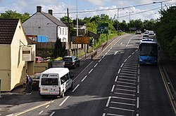
 The A38 through Lulsgate Bottom | |
| Location | |
| Grid reference: | ST512656 |
| Location: | 51°23’16"N, 2°42’8"W |
| Data | |
| Postcode: | BS48 |
| Local Government | |
| Council: | North Somerset |
Lulsgate Bottom is a little village in Somerset, running along a lane at the northern perimeter of Bristol Airport, and the A38 which leads from Bristol itself, just to the north-east of the village. The airport dominates the landscape and village.
The Church of England church here stands on nearby Feltham Common and bears an interesting name: St Katharine and The Noble Army of Martyrs.
