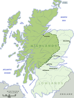
Lowlands
The Lowlands are an undefined place but a cultural and historic region: the term refers in general to all those parts of Scotland which are not within the Highlands. In the Gaelic language of the Highlands, the Lowlands are called a' Ghalldachd, meaning "the place of the foreigner".
Geographically, mainland Scotland is divided into three distinct areas: the Highlands, the Central Lowlands (also known as the 'Midland Valley' or 'Central Belt'), and the Southern Uplands. The Lowlands may be considered to cover roughly the latter two. The northeast plain from Nairnshire and sweeping around the coastline to the pinch of the Mounth, and the plains southward of this point, are also low-lying geographically and also culturally one with the Lowlands, but in some contexts these lands find themselves grouped together with the Highlands.
Contents
Cultural divides
Culturally, the Highlands and the Lowlands were once very distinct, as if separate nations. The Highlands spoke Gaelic and were governed by clans whose chiefs behaved like independent princes, whilst Lowlands spoke English, or Scots, and acknowledged the general law of the land. The Scots language is also known by the name Lallans; the speech of the Lowlands. The Lowlands, including the eastern coastal plains, were a place of settled towns and villages, while the Highlands were trackless moorland.
After the clan system, and even Highland dress, were suppressed after the 1745 rebellion, and as roads were driven through the glens, the culture and language of the Lowlands spread into the Highlands.
Lord Macauley, son of an Argyll family, wrote:
| “ | National enmities have always been fiercest among borderers; and the enmity between the Highland borderer and the Lowland borderer along the whole frontier was the growth of ages, and was kept fresh by constant injuries. One day many square miles of pasture land were swept bare by armed plunderers from the hills. Another day a score of plaids dangled in a row on the gallows of Crieff or Stirling. Fairs were indeed held on the debatable land for the necessary interchange of commodities. But to those fairs both parties came prepared for battle; and the day often ended in bloodshed. Thus the Highlander was an object of hatred to his Saxon neighbours; and from his Saxon neighbours those Saxons who dwelt far from him learned the very little that they cared to know about his habits. When the English condescended to think of him at all,—and it was seldom that they did so,—they considered him as a filthy abject savage, a slave, a Papist, a cutthroat, and a thief. | ” |
Boundaries
The boundary of the Lowlands may be drawn in many places. The Lowland Zone is reckoned (roughly) to have its northern limit drawn wider than the northern bounds of the Central Lowlands, cast on a line between Stonehaven on the North Sea in Kincardineshire and Helensburgh on the Firth of Clyde in Dunbartonshire. Other reckoning constricts "the Highlands" behind a line drawn around the coastal plain as far as Inverness, assigning to the Lowlands those areas culturally of the Lowlands; English-speaking and outside the clan system. To the north, Caithness is "the land beyond the Highlands" and the northern isles, Orkney and Shetland while they are not considered to belong to the Lowlands, neither do they belong to the Highlands.
The Highland Boundary Fault
A geological dividing line between Lowlands and Highlands is the Highland Boundary Fault.
For other purposes, the boundary varies; but if the Boundary Fault is used, then the counties entirely in the Lowlands are: Ayrshire, Berwickshire, Clackmannanshire, Dumfriesshire, East Lothian, Fife, Kinross-shire, Kirkcudbrightshire, Lanarkshire, Midlothian, Peeblesshire, Renfrewshire, Roxburghshire, Selkirkshire, West Lothian and Wigtownshire.
Counties which straddle the Boundary fault include Angus, Dunbartonshire, Stirlingshire, Perthshire, Kincardineshire, Aberdeenshire, Banffshire and Morayshire.
The post-Culloden measures
There was also a legally defined Highland Line in the post-Culloden years, part of the measures taken to suppress the Gaelic culture from which the rebellion arose. (The Act of Proscription applied "within the shire of Dunbartain, on the north side of the water of Leven, Stirling on the north side of the river of Forth, Perth, Kincardin, Aberdeen, Inverness, Nairn, Cromarty, Argyle, Forfar, Bamff, Sutherland, Caithness, Elgine and Ross".)
The Central Lowlands
The term Lowlands is sometimes used in a most restricted sense to refer specifically to the Midland Valley formed of the basins of the River Forth and the River Clyde. Much of this area, which has a characteristic structure of sedimentary rocks with coal deposits, lies within the basins of the Forth and Clyde. Historically, this valley has been the most agriculturally productive region anywhere north of Yorkshire. During the 19th and early 20th centuries, coal deposits promoted concentrated industrial activity and urbanization in the Central Lowlands, where 80 percent of the population of Scotland now live. While coal mining and heavy industry have declined in the region, it remains at the centre of the regional economy, with electronics and computer manufacture and service sectors such as telecommunications, computer software, and finance.
The Middle Shires
The counties either side of what was once the borders of Scotland and England are ther Middle Shires, also known as the Borders. This is hill-girt country, overspread with the Southern Uplands are the Lake District fells. The hardy folk of these shires, once they had abandoned their lawless ways, formed a large proportion of the settlers who went west in the Plantation of Ulster in the 17th century.
References
- ↑ Macauley's History of England, Chapter XIII (Gutenberg)
