Difference between revisions of "Llanwnda, Pembrokeshire"
(Created page with "{{Infobox town |name=Llanwnda |county=Pembroke |picture=Trehilyn - geograph.org.uk - 405827.jpg |picture caption=Trehilyn farmhouse |latitude=52.0134 |longitude=-5.0147 |LG di...") |
m |
||
| Line 12: | Line 12: | ||
|dialling code=01348 | |dialling code=01348 | ||
|os grid ref=SM932395 | |os grid ref=SM932395 | ||
| − | |||
}} | }} | ||
| − | '''Llanwnda''' is a rural village and ancient parish in northern [[Pembrokeshire]]. It lies some two miles | + | '''Llanwnda''' is a rural village and ancient parish in northern [[Pembrokeshire]]. It lies some two miles north-west of the port of [[Fishguard]] and is inside the boundaries of the [[Pembrokeshire Coast National Park]]. |
To the north of the village is the rocky outcrop of Garnwnda, which was the site of a French soldiers' camp during the Battle of Fishguard. On the north side of Garnwnda is a prominent cromlech excavated by John Fenton in 1847.<ref>{{cite book|title=Archaeologia Cambrensis|date=1847|publisher=Cambrian Archaeological Association|pages=283|edition=No XII - Oct 1848|url=https://books.google.com/books?id=QLk1AAAAMAAJ&pg=PA283#v=onepage&q&f=false|accessdate=5 June 2014}}</ref> | To the north of the village is the rocky outcrop of Garnwnda, which was the site of a French soldiers' camp during the Battle of Fishguard. On the north side of Garnwnda is a prominent cromlech excavated by John Fenton in 1847.<ref>{{cite book|title=Archaeologia Cambrensis|date=1847|publisher=Cambrian Archaeological Association|pages=283|edition=No XII - Oct 1848|url=https://books.google.com/books?id=QLk1AAAAMAAJ&pg=PA283#v=onepage&q&f=false|accessdate=5 June 2014}}</ref> | ||
Latest revision as of 23:34, 12 January 2021
| Llanwnda | |
| Pembrokeshire | |
|---|---|
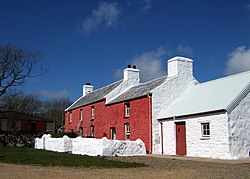
 Trehilyn farmhouse | |
| Location | |
| Grid reference: | SM932395 |
| Location: | 52°-0’48"N, 5°-0’53"W |
| Data | |
| Post town: | Goodwick |
| Postcode: | SA64 |
| Dialling code: | 01348 |
| Local Government | |
| Council: | Pembrokeshire |
| Parliamentary constituency: |
Preseli Pembrokeshire |
Llanwnda is a rural village and ancient parish in northern Pembrokeshire. It lies some two miles north-west of the port of Fishguard and is inside the boundaries of the Pembrokeshire Coast National Park.
To the north of the village is the rocky outcrop of Garnwnda, which was the site of a French soldiers' camp during the Battle of Fishguard. On the north side of Garnwnda is a prominent cromlech excavated by John Fenton in 1847.[1]
The church of St Gwyndaf is a Grade-II* listed building [2]
The community came to a degree of national prominence in the summer of 2007 following the purchase of a semi-derelict farmhouse (Trehilyn) by the broadcaster Griff Rhys Jones and the ensuing BBC television documentary, A Pembrokeshire Farmhouse, which recorded its restoration.
Outside links

References
- ↑ Archaeologia Cambrensis (No XII - Oct 1848 ed.). Cambrian Archaeological Association. 1847. pp. 283. https://books.google.com/books?id=QLk1AAAAMAAJ&pg=PA283#v=onepage&q&f=false. Retrieved 5 June 2014.
- ↑ "Church of St Gwyndaf, Llanwnda, Pencaer". British Listed Buildings. http://www.britishlistedbuildings.co.uk/wa-12980-church-of-st-gwyndaf-llanwnda-pencaer. Retrieved 30 December 2013.
- ↑ Becky Hotchin (2 January 2018). "Last invasion Llanwnda Bible to go on display". Western Telegraph. http://www.westerntelegraph.co.uk/news/15798416.Last_invasion_Llanwnda_Bible_to_go_on_display/. Retrieved 2 January 2018.