Llangollen Canal


The Llangollen Canal is a navigable canal which links Llangollen in Denbighshire with Hurleston in Cheshire, by way of the town of Ellesmere in Shropshire (map). It was built for industry but is used now mainly for leisure.
In 2009 an eleven-mile section of the canal from Gledrid Bridge near Rhoswiel through to the Horseshoe Falls, which includes Chirk Aqueduct and Pontcysyllte Aqueduct, was declared a World Heritage site by UNESCO.[1]
The waterway, from which the modern canal takes it name, was built when work to complete the Ellesmere Canal was halted in the early 19th century. The Ellesmere Canal was to be a commercial waterway that linked the Port of Liverpool to the industrial centres of the Black Country and Birmingham, but due to a variety of problems, such as rising costs and rival competition, the scheme was never finished as intended. As the waterway never reached its proposed main source of water at Moss Valley, a feeder channel was constructed along the side of the Vale of Llangollen to the River Dee; the work created the Horseshoe Falls at Llantisilio.
The Llangollen line became the primary water source from the River Dee for the central section of the incomplete Ellesmere Canal. As such it was not built as a broad-gauge waterway but as a navigable feeder branch. Eventually the Ellesmere Canal became part of the Shropshire Union network in 1846.
In the 1980s, British Waterways took the decision to rename the surviving central sections of the Ellesmere Canal as the Llangollen Canal. As a rebranding of Britain's industrial waterways as leisure destinations, it has encouraged usage and promoted restoration.
Contents
History

The grand plan for the Ellesmere Canal was to link the River Mersey with the River Severn. The northward section would begin at Netherpool (now Ellesmere Port) using part of the existing Chester Canal before reaching the River Dee at Chester. The southerly section of the waterway would pass through Overton before heading towards Shrewsbury.
Although work commenced in 1795, the canal was never finished as intended even though major works included two aqueducts at Pontcysyllte and Chirk as well the Chirk Tunnel. Only the southerly section from Lower Frankton to Weston Lullingfields was completed. The final 9 miles to Shrewsbury was never started because of financial problems.
Only a short length of the northern section beyond Trevor Basin was built. It was infilled when the canal company decided not to proceed because of rising costs and resistance from property holders to sell their land. The failure to reach the main water source north of Wrexham prompted the creation of the Llangollen feeder from the Horseshoe Falls. The weir, which created the man-made falls on the River Dee, provided water for this part of the network.
Eventually the Ellesmere canal was completed between Frankton Junction to Ellesmere and Whitchurch in Shropshire, eventually reaching the Chester Canal at Hurleston Junction near Nantwich, Cheshire.
The surviving sections of the Ellesmere Canal became part of the Shropshire Union Canal network in 1846.
Decline
Commercial traffic on the canal greatly declined after a waterway breach near Newtown, Montgomeryshire (now part of the Montgomery Canal) in 1936. By 1939 boat movements on the canal between Hurleston to Llangollen had ceased. The canal was formally closed to navigation under the London Midland and Scottish Railway Company Act of 1944. On 6 September 1945, due to inadequate maintenance, the canal breached its banks east of Llangollen near Sun Bank Halt. The flow of hundreds of tons of water washed away the embankment of the railway further down the hill, tearing a 40 yd crater 50 ft deep.[2] This caused the first traffic of the morning, a mail and goods train composed of 16 carriages and two vans, to crash into the breach, killing one and injuring two engine crew.[3]
However, despite its official closure to waterway traffic, the canal was not in-filled or allowed to remain de-watered because it was still required as a water feeder for the Shropshire Union Canal. It also provided a supply of drinking water to a reservoir at Hurleston. In 1955 the Mid & South East Cheshire Water Board agreed to maintain the canal securing its future.
Restoration
In the latter half of the 20th century canal usage for leisure boating grew in popularity. The "Llangollen Branch of the Shropshire Union" became popular due to its aqueducts and scenery. The canal was later renamed the Llangollen Canal becoming one of the most popular canals for holidaymakers in Britain.
Sights along the canal
The canal's most notable features include the spectacular Pontcysyllte Aqueduct built by Thomas Telford. Opened in 1805, the aqueduct is more than 980 feet long and 125 feet above the valley floor. It has nineteen stone arches, each with a forty-five foot span. Another aqueduct carries the canal over the River Ceiriog at Chirk, and there are tunnels nearby at Whitehouses, Chirk, and Ellesmere.
The canal also passes between the Fenn's, Whixall and Bettisfield Mosses National Nature Reserves.
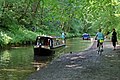
The canal and towpath
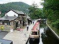
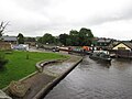
Llangollen canal wharf
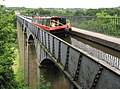
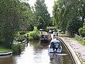
A canal boat traverses the Pontcysyllte Aqueduct
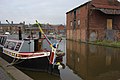
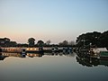
Ellesmere Basin
.jpg)


Route
Hurleston to Frankton Junction
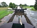
The canal at Hurleston Junction rises from the Shropshire Union Canal main line, through four adjacent locks.
Wrenbury lift bridge is operated by use of a British Waterways key, and involves closing barriers and stopping traffic on a sometimes-busy road.
At Grindley Brook the canal passes through three locks and a three-chamber staircase lock, attended during summer months by a lock keeper.
At Whitchurch a short arm of the canal remains open. Originally this continued almost to the centre of the town, though sections have since been built over. Whitchurch Waterway Trust promotes the restoration of this arm.
Between bridges 44 and 47 the canal passes through Whixall Moss.
Adjacent to bridge 46 is Whixall Moss Junction leading to the Prees Branch.
Between bridges 54 and 57 the canal passes the Ellesmere meres.
At Ellesmere there is a short arm towards the town.
The canal also passes though Burland, Quoisley Bridge, and Bettisfield, the latter in a detached part of Flintshire.
Prees Branch
The Prees Arm of the canal was originally intended to reach Prees, it was only constructed as far as Quina Brook, and today is only open for a short distance, with two lift bridges, to a marina at the end. The first bridge (Allman's Bridge) being one of the last manual lift bridges to be finally converted to hydraulic in 2010.
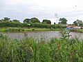
Evening over Whixall Marina

Frankton Junction to Trevor Basin
At Frankton Junction the Montgomery Canal, which is partially restored, heads southwards. For historic reasons the bridge numbering continues down the Montgomery Canal and a second bridge numbering series for the Llangollen Canal begins with Rowson's Bridge (which is numbered both 1W and 70). The "W" addition is a recent act by British Waterways, to avoid possible confusion, especially for emergency services, of having different bridges on the same canal with the same number.
The Llangollen Canal passes through Hindford, Saint Martin's, Preesgweene, Chirk Bank, Chirk and Froncysyllte, and includes the Chirk Aqueduct, the Chirk Tunnel and the Pontcysyllte Aqueduct.
Frankton Junction
New Marton Bottom Lock
New Marton Top Lock
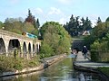
Chirk Aqueduct
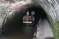
Chirk Tunnel
Trevor Basin


Trevor Basin to Horseshoe Falls
This section was built as a navigable feeder and is both shallow and narrow. Some sections near Llangollen are too narrow for boats to pass each other and it is necessary to scout ahead to check for oncoming boats.
Navigation by powered craft is prohibited beyond the entrance to Llangollen Marina and the final section is used only by the horse drawn trip boats. British Waterways maintains a gravel shoal immediately upstream of the marina entrance past Llangollen Wharf. This maintains a draft which most narrowboats cannot pass, but which is passable by the shallow drafted trip boats.
In 2005, a marina was constructed by British Waterways, just upstream from Llangollen Wharf, to relieve the acute shortage of casual moorings. A charge is made for all moorings over 48 hours at Llangollen. About 100 yards downstream of the wharf there are about a dozen 'visitor' moorings complete with individual electricity and water at each.
Outside links
- Route map
- Llangollen Canal - North Wales Borderlands website
References
- ↑ "Unesco names Pontcysyllte aqueduct as UK's latest World Heritage site". The Times (London). 2009-06-28. http://entertainment.timesonline.co.uk/tol/arts_and_entertainment/visual_arts/architecture_and_design/article6594604.ece. Retrieved 2010-01-12.
- ↑ The Shell Book of Inland Waterways (Hugh McKnight), 1987 ISBN0-7153-8239-X, page=28
- ↑ "BBC News - North East Wales". Bbc.co.uk. 1970-01-01. http://www.bbc.co.uk/wales/northeast/sites/denbighshire/pages/int-eist1.shtml. Retrieved 2013-05-29.
| ("Wikimedia Commons" has material about Llangollen Canal) |
- Denton, John Horsley (1984). Montgomershire Canal and the Llanymynech Branch of the Ellesmere Canal. Lapal Publications. ISBN 0-9509238-1-8.
- Waterways World (2005). Canal Guide 2 - Llangollen and Montgomery Canals. Waterways World Ltd. ISBN 1-870002-89-X.