Llanarth, Cardiganshire
From Wikishire
| Llanarth | |
| Cardiganshire | |
|---|---|
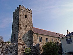
 St David's parish church | |
| Location | |
| Grid reference: | SN423575 |
| Location: | 52°11’38"N, 4°18’25"W |
| Data | |
| Post town: | Llanarth |
| Postcode: | SA47 |
| Dialling code: | 01545 |
| Local Government | |
| Council: | Ceredigion |
| Parliamentary constituency: |
Ceredigion |
Llanarth is a small village in Cardiganshire located on the A487 road between Aberystwyth and Cardigan within three miles of both Aberaeron and New Quay.
Amenities
In Llanarth, there is a petrol station, post office, a primary school, a public house (the Llanina Arms), a butcher, a convenience store and a garden centre.
The parish church of St David's, once dedicated to St Fylltyg, is a grade II* listed building. It was renovated in 1872. [1]
References
- ↑ "Church of Saint David, Llanarth". British Listed Buildinds. http://www.britishlistedbuildings.co.uk/wa-9768-church-of-saint-david-llanarth. Retrieved 18 December 2013.