Little Totham
| Little Totham | |
| Essex | |
|---|---|
 The Swan | |
| Location | |
| Grid reference: | TL889118 |
| Location: | 51°46’26"N, 0°44’17"E |
| Data | |
| Population: | 400 (2011[1]) |
| Post town: | Maldon |
| Postcode: | CM9 |
| Dialling code: | 01621 |
| Local Government | |
| Council: | Maldon |
| Parliamentary constituency: |
Witham |
Little Totham is a village and parish in Essex. The parish extends from the extensive common and heath-land of Tiptree down to the River Blackwater. The village lies about six miles from Maldon and five miles from Tiptree and lies on the back road between Goldhanger and the Maldon to Colchester road. The population was measured at 400 in the 2011 Census.[1]
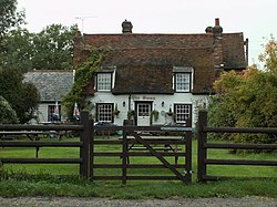
Most of the population live on the edge of the parish adjoining Tolleshunt Major and centred on the main road running through the village past The Swan public house and children’s play area. The rest of the parish is agricultural and the roads and field patterns remain much as they were at the Domesday survey of 1085.
History
The halls of Little Totham and Rook Hall have their origins in the 12th century, and the architecture of this period is seen in the North and South doorways of the parish church of All Saints, which lies adjacent to Little Totham Hall (Farm) in the centre of the parish. The parish church has an active community which provides community support in the form of pastoral visits, caring and community activities. This 12th-century church houses one of the oldest recorded stone doorways in the country (c. AD 1085), and there is a comprehensive history document within the church.
The present main road through the village was originally a track used by smugglers bringing liqueur, silks and other cloths from the River Blackwater to the plains where travellers would exchange them for money. In Little Totham, on the edge of the River Blackwater and in the fields near Osea Island there is evidence of man dwelling there from as far back as the Bronze Age 6,000 years ago. There is evidence of the smelting of ores using the wood from the extensive forests which covered the area.
The main farms developed in the area in the 11th century, and life revolved around these until the development of the dwellings along the smugglers' route in the late 16th century. Notably among these is the White Horse (now the White House), which was a pub and boarding house until the beginning of the 20th century. There are extensive patterns of footpaths across the area which lead to the farms and were developed by farm workers walking to and from work. There has always been a history of itinerant workers both on the farms and in the smuggling trade and these have over the years rested, albeit temporarily, on the Totham plains.
'The Plains' which form some of the largest areas of common land in the country are within the village boundary and there are many pleasant walks across them.
In the mid- to late 19th and early 20th centuries more substantial farm workers' cottages were built around the "main" road and the village grew. In the late 19th century three more ale houses sprang up to deal with the thirst of these farm workers. The 17th-century residential property near the extensive village pond became The Swan Ale House and more latterly a Public House. Further along the road the White Hart (now demolished) was for a period an ale house and off-licence. Along Plains Road, The Eagle (now a private house) was an ale house mainly serving itinerant travellers who came seasonally to work on the land. It was at this time that the Peculiar People's Chapel was built on the common. This is still an active Evangelical Church.
The present village is a mixture of these old houses and more modern development, and the community is a mixture of people. People who work from home, commute to Maldon, Witham, Chelmsford, Colchester and London, are retired or craftsmen. The farms are still working mainly arable crops, present cereals and rape. There are hen and turkey farms, pigs and sheep. There has been some diversification where gravel has been extracted and the land laid down to lakes for nature trails and fishing.
References
| ("Wikimedia Commons" has material about Little Totham) |
- ↑ 1.0 1.1 "Parish population 2011". Neighbourhood Statistics. Office for National Statistics. http://www.neighbourhood.statistics.gov.uk/dissemination/LeadKeyFigures.do?a=7&b=11125756&c=CM9+4RB&d=16&e=62&g=6425375&i=1001x1003x1032x1004&m=0&r=0&s=1442932007489&enc=1. Retrieved 22 September 2015.