Little Rollright
| Little Rollright | |
| Oxfordshire | |
|---|---|
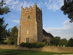
 St Philip's parish church | |
| Location | |
| Grid reference: | SP293301 |
| Location: | 51°58’5"N, 1°34’34"W |
| Data | |
| Post town: | Chipping Norton |
| Postcode: | OX7 |
| Dialling code: | 01608 |
| Local Government | |
| Council: | West Oxfordshire |
| Parliamentary constituency: |
Witney |
Little Rollright is a hamlet in western Oxfordshire, about three miles north-west of Chipping Norton, close by the border with Warwickshire to the north and west, and close by the bounds of Gloucestershire. It is the village nearest to the megalithic Rollright Stones. An early spelling may be seen, its Latin form, as Parva Rolrandryght in 1446.
In 1931 the parish had a recorded population of 10. Its population has not been separately recorded since then.
Parish church
The earliest parts of the Church of England parish church, St Philip are of the 13th-century, and include the chancel arch and buttresses. The present south windows of the chancel were inserted in the 15th century. The nave was rebuilt in the 16th century. The tower was built or rebuilt in 1617. The south porch and doorway, and a five-light window on the south side of the nave may be of the same date.[1]
Inside the church are two 17th-century monuments to members of the Dixon family.
The church is a Grade II* listed building.[2]
Outside links
| ("Wikimedia Commons" has material about Little Rollright) |
References
- ↑ Sherwood & Pevsner 1974, p. 690.
- ↑ National Heritage List 1251364: Church of St Philip (Grade II* listing)
- Nikolaus Pevsner: The Buildings of England: Oxfordshire, 1974 Penguin Books ISBN 978-0-300-09639-2page 690