Difference between revisions of "Lea, Herefordshire"
From Wikishire
(Created page with "{{Infobox town |name=Lea |county 1=Hereford |county 2=Gloucester |latitude=51.8931 |longitude=-2.4989 |picture=Lea Church, Herefordshire - geograph.org.uk - 58374.jpg |picture...") |
|||
| Line 15: | Line 15: | ||
|os grid ref=SO655214 | |os grid ref=SO655214 | ||
}} | }} | ||
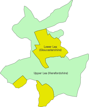
| − | '''Lea''' is a village and civil parish in the south-east of [[Herefordshire]], just south-east of [[Ross-on-Wye]] and adjoining [[Gloucestershire]]. | + | '''Lea''' is a village and civil parish in the south-east of [[Herefordshire]], just south-east of [[Ross-on-Wye]] and adjoining [[Gloucestershire]]. The ancient parish is divided into the townships of Lea Upper in Herefordshire and Lea Lower in Gloucestershire. |
Amenities in the village include a school, church, village hall, shop, public house, garage and Post Office, all of which lie on the A40 road which passes through the village. | Amenities in the village include a school, church, village hall, shop, public house, garage and Post Office, all of which lie on the A40 road which passes through the village. | ||
| Line 29: | Line 29: | ||
*[http://www.theleaparishcouncil.org.uk/ Lea Parish Council] | *[http://www.theleaparishcouncil.org.uk/ Lea Parish Council] | ||
*[http://www.alankeef.co.uk Alan Keef Ltd] | *[http://www.alankeef.co.uk Alan Keef Ltd] | ||
| + | [[File:Upper and Lower Lea.svg|thumb|left|300px|The ancient parish of Lea, showing the division into townships]] | ||
{{stub}} | {{stub}} | ||
Latest revision as of 15:21, 23 February 2022
| Lea | |
| Herefordshire, Gloucestershire | |
|---|---|
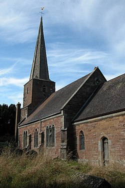
 Church of St John the Baptist, Lea | |
| Location | |
| Grid reference: | SO655214 |
| Location: | 51°53’35"N, 2°29’56"W |
| Data | |
| Population: | 673 (2011[1]) |
| Post town: | Ross-on-Wye |
| Postcode: | HR9 |
| Dialling code: | 01989 |
| Local Government | |
| Parliamentary constituency: |
Hereford and South Herefordshire |
Lea is a village and civil parish in the south-east of Herefordshire, just south-east of Ross-on-Wye and adjoining Gloucestershire. The ancient parish is divided into the townships of Lea Upper in Herefordshire and Lea Lower in Gloucestershire.
Amenities in the village include a school, church, village hall, shop, public house, garage and Post Office, all of which lie on the A40 road which passes through the village.
The railway engineering company Alan Keef Ltd has its headquarters on the outskirts of the village.[2]
Between 1855 and 1964, Lea was served by Mitcheldean Road railway station on the Hereford, Ross and Gloucester Railway.
References
- ↑ "Civil Parish population 2011". http://www.neighbourhood.statistics.gov.uk/dissemination/LeadKeyFigures.do?a=7&b=11125496&c=HR9+7JZ&d=16&e=62&g=6386087&i=1001x1003x1032x1004&m=0&r=0&s=1446378561375&enc=1. Retrieved 31 October 2015.
- ↑ "Alan Keef Ltd - Light Railway Engineers & Industrial Locomotive Builders:". http://www.alankeef.co.uk. Retrieved 30 December 2013.
