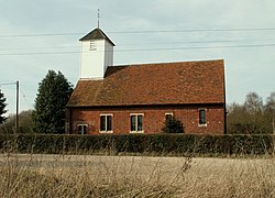
Layer Breton
| Layer Breton | |
| Essex | |
|---|---|
 St Mary's Church | |
| Location | |
| Location: | 51°49’48"N, 0°49’16"E |
| Data | |
| Population: | 287 |
| Post town: | Colchester |
| Postcode: | CO2 |
| Dialling code: | 01206 |
| Local Government | |
| Council: | Colchester |
| Parliamentary constituency: |
Witham |
Layer Breton is a village and parish in the hundred of Winstree, Essex. According to the 2011 census the population was 287, comprising 144 males and 143 females.[1]
Layer Breton is part of the Layer parishes with Layer de la Haye being the neighbouring village to the west and Layer Marney neighbouring Layer Breton to the east. The village has a church dedicated to St Mary the Virgin, rebuilt in brick in 1923 on a new site nearly a mile to the north of the old one. The village was among those which suffered damage from the 1884 Colchester earthquake.
History
In the 1870s, John Marius Wilson's Imperial Gazetteer of England and Wales described Layer Breton as:
"A parish, with a village, in Lexden district, Essex. Post town, Kelvedon. Acres, 954. Real property, £1, 763. Pop., 298. Houses, 62. The property is divided among a few. The living is a rectory in the diocese of Rochester. Value, £350. * Patron, the Rev. W. Blow. The church is tolerable. There are chapels for Independents and Quakers; and the Independent one was rebuilt and enlarged in 1860."
Name
The name Layer Breton originally came from a river name of Celtic origins, 'Leire', most likely to be identical with one found in Leicester. Lewis Brito ('the Breton') gave land here to St John's Abbey, Colchester in the 12th century.[2]
Churches
St Mary's Anglican Church stands next to the Heath in the main part of the village. It was built in 1915. The original church stood opposite Layer Breton Hall. It was demolished in 1913 following the 1884 Colchester earthquake . "A watercolour painting of the old church, which was painted shortly before the demolition, hangs in the new church. It shows that the old building was of a similar shape and size to the new, having a vestry behind the altar and a wooden porch. It had a wooden bell turret as does the new building. It was of rubble construction with a tiled roof. The modern church is of brick construction with tiles.There was a church on the old site from at least Norman times. The old church probably dated from the 14th century."[3] St Mary The Virgin church it is part of a group of seven parishes of which belong to the Benefice of Thurstable and Winstree which came into being on 1 October 2013. The other six parishes in the benefice are Tolleshunt Knights with Tiptree, Great Braxted, Messing, Inworth, Copford and Easthorpe.[4]
Transport
There are no railway stations in Layer Breton; the closest station is Marks Tey Rail Station which is four miles away. Destinations from this station include Ipswich, Colchester, Clacton-on-Sea and London Liverpool Street.[5] No buses run on a Sunday in Layer Breton. On weekdays they vary from 6 to 8 buses a day into nearby parishes Birch and Layer De La Haye. Buses also run into Colchester, destinations including Colchester Zoo and Colchester Hospital. Other destinations the bus goes to are Tollgate, Shrub end, Heckfordbridge, Great Wiborough, Salcott, Tollesbury and Tolleshunt Darcy.[6]
References
- ↑ ""Layer Breton (Parish):Key Figures for the 2011 Census :Key Statistics"". 2 February 2017. http://www.neighbourhood.statistics.gov.uk/dissemination/LeadKeyFigures.do?a=7&b=11125490&c=CO2+0PN&d=16&e=62&g=6424188&i=1001x1003x1032x1004&m=0&r=0&s=1443450880409&enc=1. Retrieved 28 September 2015.
- ↑ Of place, History (28 March 2017). "Name of layer Breton". http://kepn.nottingham.ac.uk/map/place/Essex/Layer%20Breton. Retrieved 28 March 2017.
- ↑ Domesday reloaded, BBC (30 March 2017). "Church". http://www.bbc.co.uk/history/domesday/dblock/GB-592000-216000/page/15. Retrieved 30 March 2017.
- ↑ "The 'Layer' Parishes". http://www.layerchurches.org.uk/. Retrieved 21 March 2017.
- ↑ Rail, National (28 March 2017). "trains". http://ojp.nationalrail.co.uk/service/ldbboard/arr/MKT. Retrieved 28 March 2017.
- ↑ "Local Bus Times". http://www.carlberry.co.uk/rfnshowl.asp?L1=LAY0060.