Langrick
| Langrick | |
| Lincolnshire | |
|---|---|
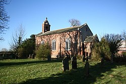
 St Margaret's Church, Langrick | |
| Location | |
| Grid reference: | TF271489 |
| Location: | 53°1’21"N, 0°6’22"W |
| Data | |
| Post town: | Boston |
| Postcode: | PE22 |
| Local Government | |
| Council: | East Lindsey |
| Parliamentary constituency: |
Boston and Skegness |
Langrick is a small village in Lindsey, the northern part of Lincolnshire, on the B1192 road, five miles north-west of Boston. The village stands within the Lincolnshire Fens, and less than a mile east of the River Witham.
History
The name 'Langrick' appears to come from "Long Creek"[1] and is at the very southern edge of Wildmore Fen, in an area which was once the manor of Armtree, in the parish of Coningsby.[2] It was once the site of a hermitage belonging to Kirkstead Abbey.
When Langrick and Langriville were enclosed in 1812 there was not a single house existing.[3] Langrick's importance was that it was the site of a ferry crossing over the Witham,[3] reputedly established by Robert Dymoke.[2] The river was straightened in 1833.[3]
A steel bridge, still in use, was built in the southern neighbouring settlement of Langrick Ferry in 1909, replacing a previous ferry over the Witham.[3]
Church
The parish church, St Margaret of Scotland, was built in 1828,[3] probably by Jeptha Pacey, but was not dedicated until 20 April 1922.[4] It is a Grade II listed building and was restored and altered in 1885.[5]
The church was restored again and redecorated in 1935, and further work was carried out in 1968.
Today, the church forms part of the Brothertoft Group, in the Diocese of Lincoln, also known as 'Five in the Fen', which are:
- St Gilbert of Sempringham, Brothertoft
- All Saints, Holland Fen
- Christ Church, Kirton Holme
- St Margaret, Langrick
- St Peter, Wildmore
About the village
There was once a railway station here, on the now dismantled Great Northern Railway railway line between Lincoln and Boston.[3] A café stands on the site of the station master's house and booking office.[6]
The Water Rail Way follows the route of the old dismantled railway line from Lincoln to Boston and can be joined at Langrick.[7]
Near the site of the old railway line is the Ferry Boat Inn public house.[8]
Outside links
| ("Wikimedia Commons" has material about Langrick) |
References
- ↑ Pishey Thompson (1856). The History & Antiquities of Boston. Longman & Co. p. 360. https://archive.org/details/bostonantiquity00thomuoft. Retrieved 8 February 2012.
- ↑ 2.0 2.1 Pishey Thompson (1856). The History & Antiquities of Boston. Longman & Co. p. 622. https://archive.org/details/bostonantiquity00thomuoft. Retrieved 8 February 2012.
- ↑ 3.0 3.1 3.2 3.3 3.4 3.5 "Boston UK". Langrick. Visitor uk.com. http://www.bostonuk.com/historydetail.php?id=634&f=Boston. Retrieved 20 April 2011.
- ↑ "Langriville Parish Council Website". http://parishes.lincolnshire.gov.uk/Langriville/section.asp?catId=14392. Retrieved 21 April 2011.
- ↑ National Heritage List St Margaret, Langrick: Margaret, Langrick 1359725 (Grade II listing)
- ↑ "Langrick". Disused Stations. Subterranea Britannica. http://www.disused-stations.org.uk/l/langrick/index.shtml. Retrieved 24 August 2011.
- ↑ "Water Rail Way". Sustrans Org. http://www.sustrans.org.uk/sustrans-near-you/midlands/easy-rides-in-the-midlands/water-rail-way. Retrieved 21 April 2011.
- ↑ "Ferry Boat Inn". Information Britain. http://www.information-britain.co.uk/showPlace.cfm?Place_ID=36711. Retrieved 24 August 2011.